Chicago Tribune, January 4, 1910
Without a single negative vote the ordinance which provides for turning Michigan avenue from Jackson boulevard to Randolph street over to the custody of the south park board passed the city council last night.
Sixty-two votes were recorded in favor of the proposition to continue the boulevarding of the street north. The park board will take possession immediately and the work of transforming the thoroughfare will be started soon.
Chicago Tribune, January 9, 1910
As a sort of New Year’s resolve the Chicago city council the other day turned over to the south park commissioners almost the last vestige of Michigan avenue for dedication as “Michigan boulevard.”
For half a century a neglected border line of early Chicago, along which war raged with Indians, with the northeasters from the bosom of Lake Michigan, with encroaching selfish interests of early settlers, the idea of & Michigan boulevard would have stunned an early investor in Lake street.
But as the years went on Jean Baptiste Beaubien’s fight for his home on a corner of the Michigan avenue that was to be was little more than a mere disturbance of the peace compared to a charge of a cavalry regiment. Almost the last of the dedicated thoroughfares along the lake shore off the downtown district. Michigan avenue has been the firing line of disputations such as have made tomes of court history and precedent.
Officially Michigan avenue began with a west line only, which has been its firing line for half a century between Madison and Twelfth streets at least. But in these years frontier conditions have not obtained. With only a west line to begin with, Michigan avenue has developed that west line and stretched on southward until today—despite all legal and illegal contentions as to its lake horizons—It lies the incomparable boulevard of boulevards of both the Chicago “homely” and the “Chicago beautiful.
Start as Indian Trail.
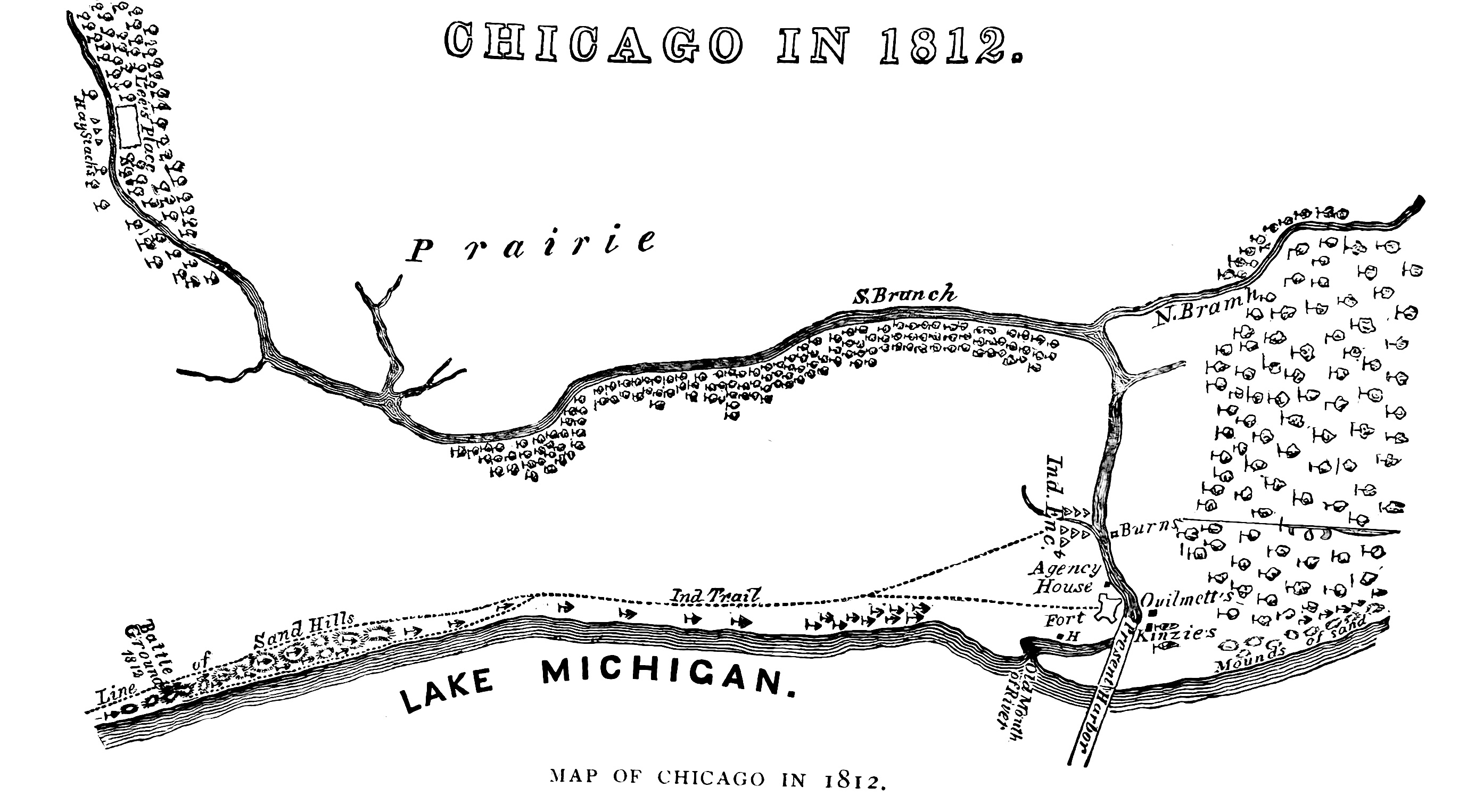
A hundred years ago, when Fort Dearborn at the mouth of the Chicago river stood as the germ of the present second city of the country, the Indian and the trapper and the traveler of the time laid out Michigan boulevard in beating out a trail from the south to the gates of the old fort.
But the early settler in Chicago knew his Chicago was extending no further south than Madison street and was concerned with it no further east than State street, which was the western line of the military reservation on which the old fort stood.
Years after Chicago had become an Incorporated city under Illinois laws, Michigan boulevard still was little more than a beaten path along the water front, with State street the eastern boundary of the corporate limits. In those days Madison street was the south line of the Fort Dearborn reservation. East of the city line of State street and south to Twelfth street was that fractional portion of section 15, known as “canal lands.” Not until 1852 was “Michigan avenue” suggested by name and then in connection with the franchise of the Illinois Central railway’s right of way into Chicago.
At that time only the western line of Michigan avenue was named, fixing it at a line “400 feet west of the western boundary” of the right of way of the railroad, whose eastern line of rights was extended 700 feet east of this west line of Michigan avenue. Still later the Illinois legislature fixed the eastern line of Michigan avenue, and still later the Chicago municipal code prepared the way for widening that portion of the avenue north of Washington street.
Protection of Fort Needed.
But in the Michigan boulevard in its embryo Indian trail south from Fort Dearborn, the embryo Chicago of the early ’30s indicated little interest. Fort Dearborn naturally had been planted where it might command the river. Chicago in Its early building not only wanted the protection of the fort, but it was interested in the commerce of the river. To both these ends the Chicago of 1833 was built largely along the south line of the present South Water street, from the reservation west toward the forks of the river at Wolf’s point. There were times when
a building site on Water or Lake streets might have commanded ten such sites on the future Michigan boulevard, forty rods south of that early Chicago business center.
It was in 1883 that a traveler, writing of Chicago of the time, visited it, coming by the old Indian trail which marked Michigan boulevard that was to be. He had little eye for the lake rim as his description shows
- Approaching the village by land from the south, one would see on emerging from the oak woods near Twenty-third street a good stretch of level grass, the lake on the right, woods along the borders of the main river, and, lying on the background of the green woods, only a thin cloud of smoke from the shanty chimneys, a line of almost indefinable structures, and the flag over the fort, if per chance it were fighting.
A brown path where the grass had been trodden out led to the fort, and another, better trodden and wider, led across the prairie towards the forks where the Sauganash hotel then flourished.
Boulevard Long Passed By.
The original Chicago as laid out showed its ignorance of the future Michigan boulevard and continued to do so as later it grew to city proportions and stretched itself toward three points of the compass.
This town of 1833 was platted to extend north to Kinzie street, street, west to Desplaines south to Madison street, and northward again on the section line of State street. Madison street at the time was the southern boundary of the Fort Dearborn reservation lying within the loop of the river, which then was the north and east boundaries of the reservation. Thus that earliest Indian trail to conforming to Michigan avenue did not enter Chicago at all save as to the south it branched to the northwest in the direction of Wolf’s Point, crossing the town site diagonally.
But however the original Michigan avenue. as represented by this old trail to the fort was meaningless to the earliest Chicago resident, it had been marked by the blood of those militant spirits of 1812 who, after evacuation of the old Fort Dearborn, followed the trail to their death near the site of the monument at Eighteenth street. Near this point sand dunes reared themselves to the west of the strip of shore and behind these the traitorous Indians were ambushed.
Beaubien Draws First Notice.
In the land excitements of 1836 in Chicago the future Michigan avenue figured little, for the reason that it still was a trail through the reservation strip east of State street and north of Madison. It remained for John Beaubien a year before to “start something” involving the avenue’s future site. In 1881 “Long John” Wentworth made a speech in Chicago recounting Gen. Beaubien’s contested purchase of this old Fort Dearborn reservation of approximately seventy-five acres The date was May 28, 1835:
- On that day Gen. John B. Beaubien went to the public land office and purchased for $9461 the entire Fort Dearborn reservation. He had derived his military title from an election by the people, not from any conspicuous military talents, but because he had the most friends of any one in town—and he kept-them to the day of his death.
The state at that time was divided into military districts and the people elected the generals. He had lived upon the reservation for many years and he had found some law which satisfied our land officers that he was entitled to make the purchase, the same as many others have found laws under which they could purchase our lake front ever since.
The news spread. Everybody was a daily paper in those days. We had but two newspapers in those days, and both of them were weeklies. The people assembled in squads and discussed the situation. The question was raised: Did Gen. Beaubien buy the fort with the land? What were the officers to do? There was no telegraph In those days.
Gen. Beaubien was congratulated. He had an entire force of his own. A conflict between the United States troops and the state militia might ensue. Gen. Beaubien himself was in command of the militia. Would he use them to dispossess the United States forces?
Courts Knock Out Claims.
Instead of civil war, however, the matter was taken to the courts, where even in those early times matters could be kept undecided for years. The suit went to the United States Supreme court, which in 1840 knocked out the Beaubien claims and left about fifty-four acres to be platted as an addition to Chicago as it then stood.
But politics had crept into the situation. Beaubien had sold many lots, or wisely given them to political friends, and when Matthew Burchard came as solicitor of the general land office to make the sale of the reservation moves were made on all sides to prevent others from bidding against them on their holdings.
As a solution of the troublesome question, sealed bids were required of all the bidders for reservation lots. Especially it was expected that Gen. Beaubien would get the several lots he wanted at merely nominal figures. These lots were upon land just east of the present Michigan avenue, near South Water street. The corner lot upon which the general’s house stood was sold him for $225. But James H. Collins, who was one of the earliest abolitionists of the state and a man of unquestioned courage, had frowned upon the whole Beaubien matter and planned to bid for those five adjoining lots which Beaubien and his friends desired should be his. Taking the average of prices paid for Ilke lots at other sales, Collins bought the property as highest bidder for $1,049.
Collins’ Nerve Holds Firm.
For a time this purchase was a veritable brand in a powder house. Collins was burned in effigy and his life was threatened. As one of the able lawyers of his day, however, Collins’ nerve held, even to inviting the friends of Beaubien to take his life, assuring them that this by no means would be the taking of his lands.
Today in identifying the scene of this incident in the warfare which has centered in Michigan boulevard for nearly a century, the citizen needa to go only to the intersection of South Water street and Michigan avenue.
That northeast corner was the home of Gen. Beaubien from which, soon after the sale, he moved to a farm near River Park on the Desplaines river. In 1854, when the lots were vacated of the old military buildings which had made sale of them impossible, an act of congress donated these lots to the old general, and in the words of “Long John” Wentworth, who introduced the resolution, “There was not a citizen who knew him who ever to my Knowledge questioned the propriety of the act.”
With the addition of the platted reservation to the new Chicago and with the straightening of the river channel into the lake, the streets laid out from Madison street northward to the south bank of the river were named from State street—Breese street, Jerome street, Macomb place and, finally, Beaubien street, which later became the “Michigan avenue ” of the fort addition.
Showing On Old Maps.
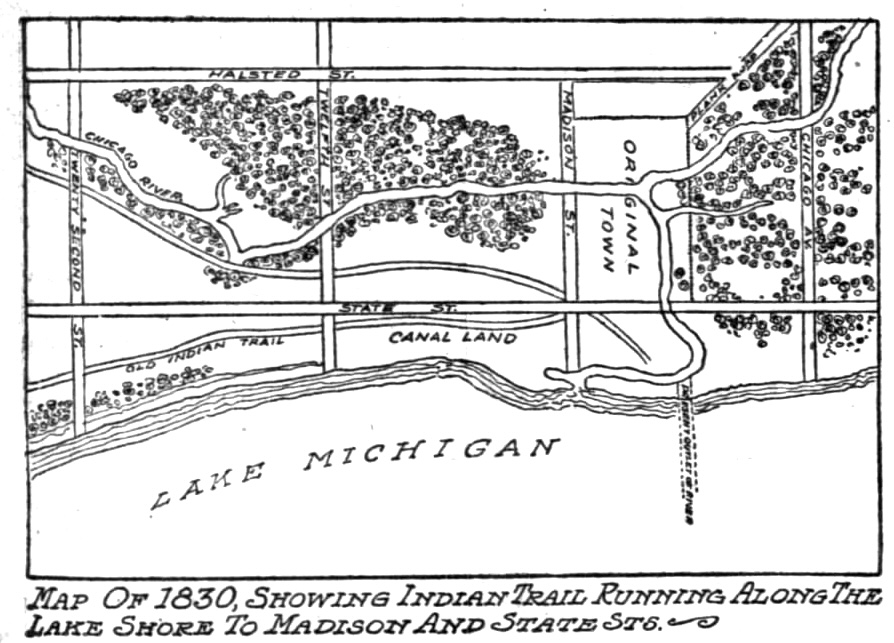
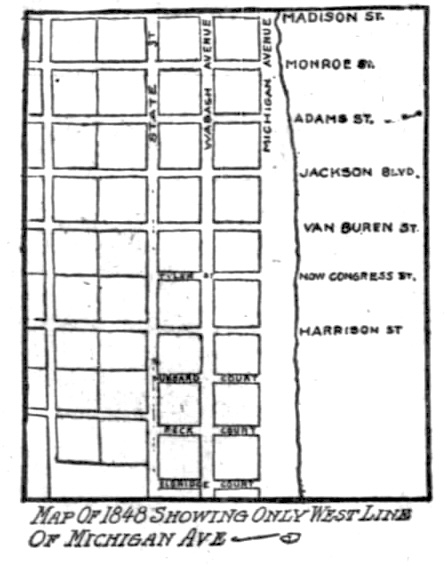
One of the old maps in the Chicago Historical society collection dated 1830, shows the present “Michigan avenue” as it leads from Randolph street to Lake street, and across South Water street to the river bank at “Harbor” street, now Rush street. On the map of the trustees of canal lands, drawn In 1848, only the west line of Michigan avenue is marked to the south of Randolph through the tractional section 15 to Twelfth street.
Thus at the time the grant was made the Illinois Central rallroad to come into the city in 1852 It was necessary to define the road’s-right of way along the present downtown city front by measurements from the west line of Michigan avenue. Seven hundred feet to the east of this west line of the avenue was to be the eastern boundary of the road’s property. while 400 feet east of this western boundary of Michigan avenue was the west line of the company’s rights. Later the state legislature defined the eastern line of the present boulevard, and in this way defined Michigan avenue Itself to the city limits on the south.
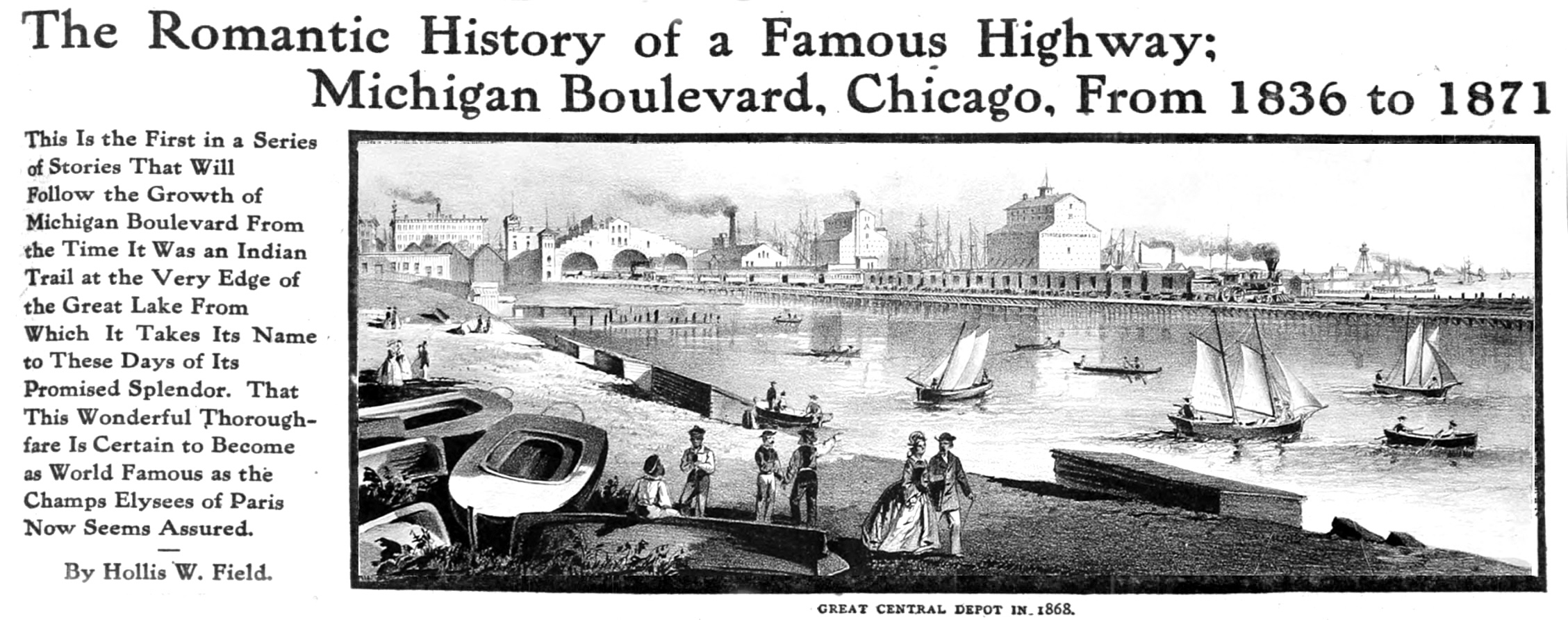
Just what Michigan avenue was in those days, however, is shown in an old wood cut illustrating the downtown water front off the foot of Madison and Monroe streets. This illustration is dated 1868, yet with the Illinois Central’s rails laid on piling, 400 feet east of the west line of Michigan avenue, the perspectives indicate that Michigan avenue itself was used principally for the landing of rowboats from the lagoon, now choked out by the filling in of Grant park.
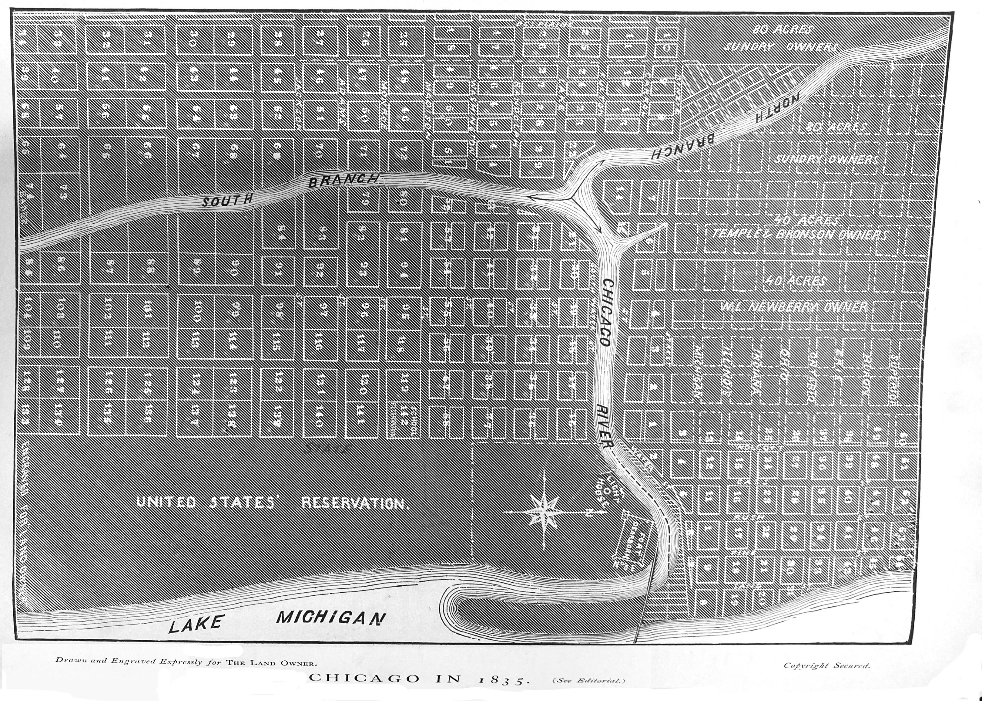
- In the August 1869 issue of The Land Owner, an 1835 map drawn by John Kinzie was discovered and the magazine redrew it for better readability.
Chicago Tribune, January 16, 1910
CHAPTER II.
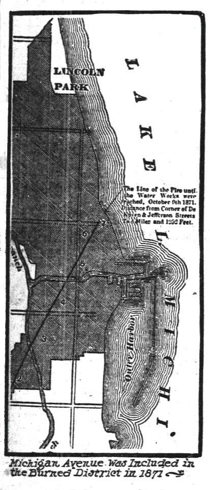
Michigan avenue, converted Indian trail and a firing line of early contentions within Chicago, needed to pass through the fire of 1871 preparatory. to entering upon its second stage of development.
As one of the fire swept avenues of the city suffered comparatively little as to the stretched burned over. Michigan terrace, the show buildings of the embryo thoroughfare, was destroyed to the south of Van Buren street. But in the vicinity of Harrison street the fire left the avenue intact southward. It appeared as if only the old firing line of controversy were to be exposed anew that it might arise out of its ashes.
With Chicago prostrated by a $200,000,000 conflagration and the bulk of its 300,000 population determined to stand by and with it lis upbuilding, Chicago needed to be fed, clothed, and provided with the materials out of which a new city should be made. A hundred thousand of these sufferers by the fire hed to be provided with shelter. With the Chicago business district wiped out and its site too hot on which to have built the pine shacks and stores that had to be erected, Lake Front park again had to be encroached upon.
Previous to the great fire and long before A. Montgomery Ward was thought of as the “watchdog of the lake front” there had been industrious residents of the old Michigan avenue, watchful and protesting against movements made toward spoilations.
“If there was an original ‘watchdog’ 0f the lakefront,” said Thomas M. Hoyne, “I feel that the distinction lies between my own father and J. T. Scammon. Mr. Scammon had invested everything he had and more in the Terrace at Van Buren street and he was paying 8 and 10 per cent interest on his borrowed capital. He and my father from the beginning had an eye on everything that resembled encroachments on the part of the railroad and one of their strongest allies was John Stafford. whose residence was on the corner of Monroe street and the avenue. Time and again I recall Mr. Stafford’s coming to our house to call attention to something he had discovered and which he wished my father to take up.”
But after the fire, virtually the whole of the ayailable east front of Michigan avenue between the river and Park row was leased by the city to business houses which had no other foundation on which to rest. It was straining a law point when Chicago justified itself to the extent of renting the park frontage in one year leases at $500 for each twenty-five feet frontage. A provision in each lease required that at the end of twelve months the building should be removed.
At once a mushroom town, mostly, wholesale houses sprang up along the east line of Michigan avenue from Randolph street south to Park row. These were plain pine fronts. but many of them stretched backward to the fall with of the “bank,” as the strip between the avenue and the shore line had been known.
Bank a Great Playgrcund.
Mr. Hoyne was a Michigan who avenue boy once played along this “bank.” In places this original stretch was 200 feet wide to the water’s edge—sufficient for ball games to be played just off Madison street, while in the neighborhood of Park row the beach rounded out into the lake much wider.
“It was somewhere about the foot of Van Buren street,” said Mr. Hoyne, that the lake cut in closest to the line of the avenue. There was a slope down to the water’s edge where horses were along ridden to water. All the water front was an open stretch which we boys called the ‘bank’ and on which we played ball both north and south of this narrow strip at Van Buren street.
“On one occasion a great storm drove in over the breakwater and cut a tremendous hole in Michigan avenue itself. so that stones had to be filled into the yawning gap. At this point, as I remember it, the sidewalk on the east side of the avenue came close up to the water’s edge, even at the time of the fire. It may have been the filling in of thie great hole in Michigan avenue which after the fire made it so easy to decide upon piling the débris into the lagoon between the avenue and the trestlework of the Illinois Central railway.
“Before this filling in after the fire, the lagoon and the ‘bank’ between the water and the eastern side of Michigan avenue served largely for boatmen and fishermen. As a boy I remember walking with other boys on the trestlework when only two tracks were laid. Occasionally when we were headed off by trains coming in each direction, we would slip down under the ties into the timbers that fastened the piling together and huddle there until the train had rumbled away overhead.”
Site of ” Richmond House.”
It was in those days that Michigan avenue and Wabash avenue were keen rivals as to which was the better and brighter residence thoroughfares Both avenues were given over largely to residences, and in that portion of Michigan avenue lying through the old Fort Dearborn reservation hotels and boarding houses clustered. At the northwest corner of Michigan avenue and South Water street was the old Richmond house. conducted by Dick Somers as the “first class ” hotel of its time.
“And it was a first class house.” said W. D. Kerfoot, recalling the time when as a young
bachelor he boarded there. “If I needed anything to back up my opinion of what a good hotel was, I’d point to the fact that when the present king of England visited Chicago as ‘Lord Renfu’ he appeared on the balcony of the Richmond house, with the streets crowded to the limits of standing room that men, women, and children might see him.
“On another corner was the Adams house. conducted by Pearce & Benjamin. Across the street was the United States Marine hospital, and the old Massasoit house was nearby. Except for these buildings, most of the former residences had been
transformed into boarding houses, while the newcomers and others built further south on Michigan avenue.
“One of the pretentious places was the home of Banker Isaac H. Burch at Monroe and Michigan avenue, built of yellow Milwaukee. brick. South of him was the residence of Fred Tuthill, and on the corner of Adams street W. S. Johnson built a white stone building, which he afterward sold to H. H Honoré. Bishop Duggan lived near the corner of Madison street. J. H: Chauncey and George Bowen had residences nearby and Silas B. Cobb occupied a gothic frame cottage in the neighborhood. Excepting the Michigan terrace, most of the other residences southward to Park row were of wood and south of Twelfth sireet were ‘squatters’ who for the most part were hard to dispossess as the avenue built on southward.”
Keen Foresight of Mr. Palmer.
Mr. Kerfoot recalls from the point of view of the real estate man, the rather singular fact that Potter Palmer was “dead set ” in confining his real estate investments to just two streets—State street and Michigan avenue. Mr. Palmer was one of the first men of the time to command a great deal of ready money, and in his judgment the two streets of promise were State street and Michigan avenue.
“Michigan avenue at the time was a distinctively residence street.” said Mr. Kerfoot, “but Potter Palmer continued to buy there. He also sold a good xxxx on the property when profits seemed large enough. But so did a lot of people sell their residence there after building and after the contentions over the lake front began. Between the frozen desert of the lake in winter and the coming of the smoking steamer stacks, which replaced the white wings of the old sailing vessels together with the respectabilities of protecting the lake shore, many of the old homesteads were moved.”
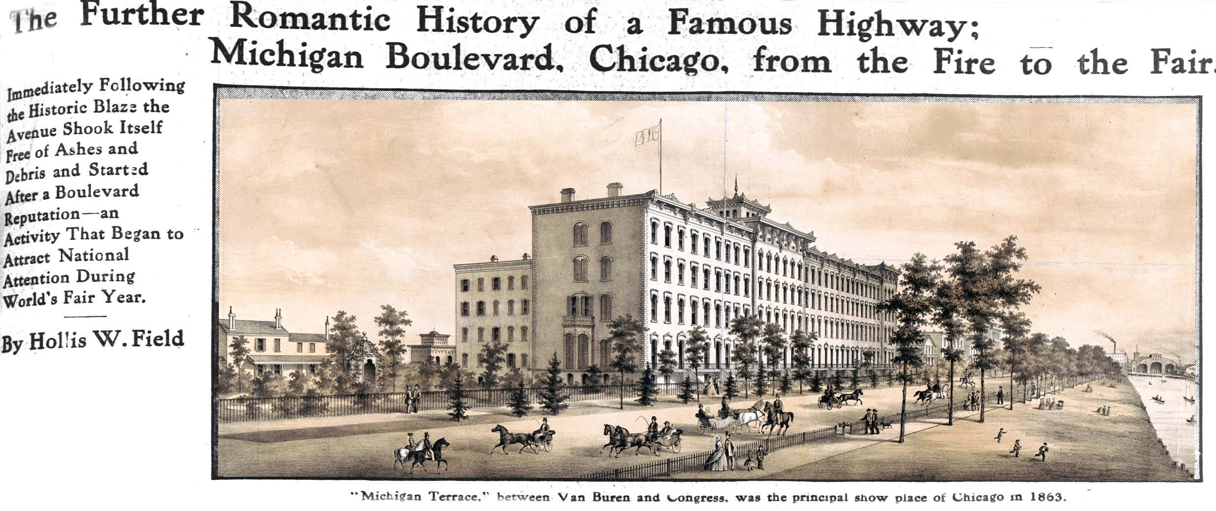
At the time of the fire Michigan terrace, on the west side of Michigan avenue and lying between Van Buren and Congress streets, was the principal show piece of architecture marking Michigan avenue.
“Terrace Row” in 1863.
J. Y. Scammon had been one of the leaders in the investment enterprise and occupied the terrace known as No. 1. Ten other families shared the great structure, which dated back to 1863 in its completeness. In its day nothing west of Philadelphia compared with it, not only in its imposing front. but in its interior finish of mahogany and plate glass.
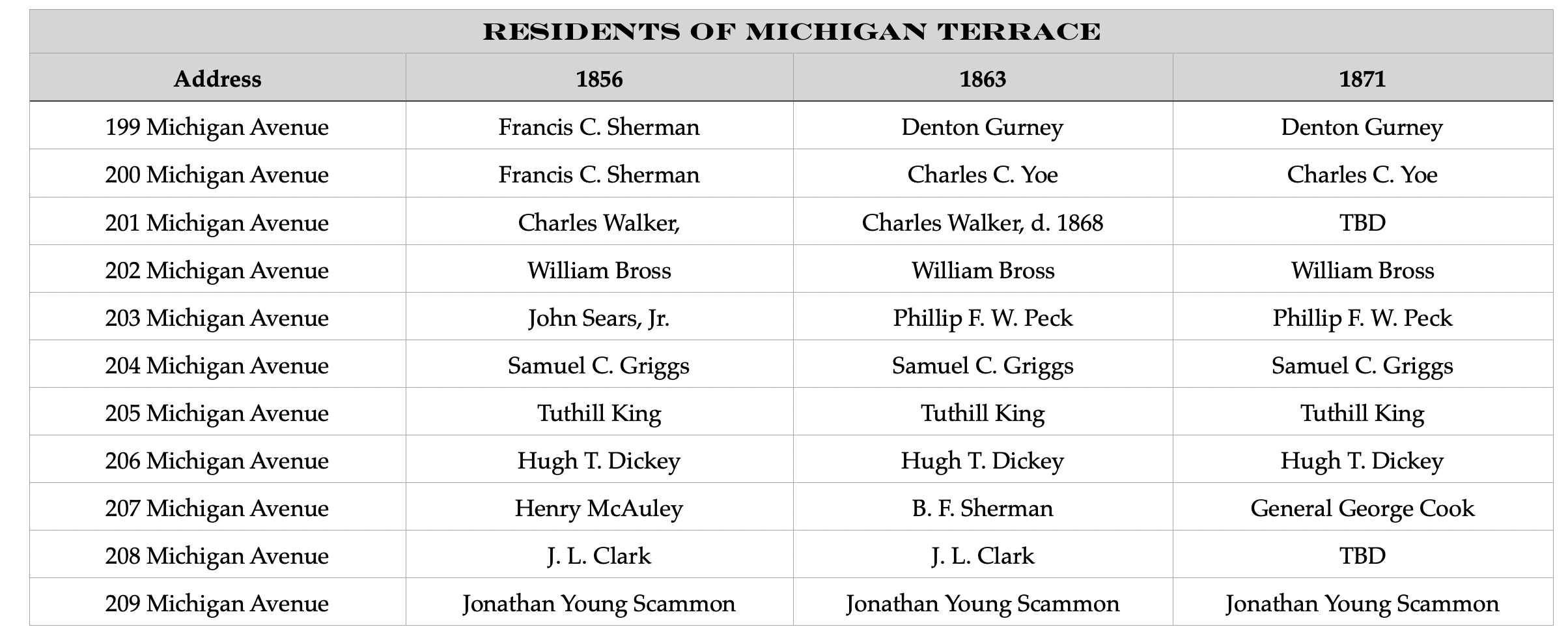
The old plate from which the picture accompanying this article was made of “Terrace row” is dated 1863 and is in the Morris bookshop, 165 Wabash avenue. Not many of these old prints were disposed of and most of them, were destroyed in the great fire. At the time this plate was made the residents of the building were:
- J. Y. Scammon, J. L. Clark, B. F. Sherman, H. T. Dickey, Tuthill King, S. C. Griggs, P. F. M. Peck, W. Bross, Chas. Walker, P. L. Yoe, Denton Gurney.
In this group of familles alone are many names connected with the development of Chicago. Michigan terrace was a social center in itself, while all around it dwelt others—mostly in frame buildings—who are inseparable from Chicago’s history.
Henry G. Foreman, president of the south park board, played as a boy along the old water front on Michigan avenue. He had no thought of the time when Michigan avenue, with its restrictions as to buildings on the park’s reserve, ever would concern him in official capacity. But he has a lively remembrance of the old time family life of the avenue and of the glories of the terrace as it developed under the hands of the builders.
After the blight of the fire the necessity for clearing the old business district of the millions of tons of debris was forced upon those who expected to rebulld. Especially It was necessary for those tenants of the lake front who had only a year’s lease to their temporary quarters to clear ground for more substantial buildings.
From the surrounding country for a hundred miles or more, farmers with wagons and teams drove into Chicago in order to avail themselves of the work of cleaning up. A teamster, wagon, and horses commanded $6 a day and often high premiums were paid over this in order that first class service might be secured.
But with all the teams to be had in Chicago and from the neighboring country, contractors for clearing away débris raised prices enormously. When Potter Palmer sought a contractor for removing the rubbish from the site of the old Field & Leiter store, the lowest bid was $5,000 for a piece of work that otherwise might hove been done for $1.000.
As a means for escaping the extortion Mr. Palmer undertook the hiring of teams and the superintendence of the work himself.
This dumping place was the first great recompense that had come to Chicago because of holding title to its lake front. Without the water basin between the shore and the right of way of the Illinois Central railway in which to dump the waste materials of the fire, the cost of clearing the downtown district might have been almost prohibitive.
As it was dumping places were set apart at most convenient distances and the rubbish of the fire, making a sold filling that was immune from decomposition went into the yawning maw of the lagoon in thousands of tons a day with the shortest possible haul It is estimated that when this dumping of refuse was at its height land was made for the city at the rate of $1,000 a day, figuring on the basis of land values of the time. What the values of this “made” land are today would be hard to estimate.
Change in First Year.
In that first year of rebullding burned Chicago the change that had come upon Michigan avenue from a residence street is shown In the totals of street frontage and cost of bullings. Old familles had drifted away from the avenue and business had not seen Its opportunity there. More than $88 000 000 was spent that year on the south side streets downtown, with the tollowing comparisons of frontage and cost of bulldings:
Speaking of this time of bullding and rebuilding, W. D. Kerfoot recalls that a New York man came here about that time, looking for a site for a business within the old limits. Lots at $1000 to $2000 a front foot were quoted to him, but he was not interested enough to buy.
One day he came into Mr. Kerfoot’s office, saying that he had made an eighty foot purchase in Michigan avenue, somewhere in the vicinity of Jackson, at $300 a front foot.
Mr. Kerfoot recalls that at the time he asked the New York man how he expected to do business “away down there?”
Progress Makes Rapid Moves.
At that time, on one of the corners of Jackson and Michigan, was a row of flats that had cost $325,000, and which had been regarded as entirely too expensive for the neighborhood. But these, it will be recalled, were torn down just before the Chicago world’s fair in order to give place to the Victoria hotel, which was considered a wonder in its day. And now the old Victoria is in ruins to give place to something more in keeping with the new Michigan boulevard of this year 1910.
It was the bullding of the Auditorium which probably attracted the first sharp attentions to the modern Michigan avenue. Both as a hotel and as a monster playhouse, the Auditorium attracted worldwide attention. the south of it Michigan avenue had been developing as one of the finest residence streets In the world. At the time of the building ef the Auditorium, that portion of the avenue north of Park Row was in a transition stage.
From the laks, however, this Michigan avenue front was the skyline of the central portion of the city, but at the time of the building of the Auditorium there was little else to mark it. Those old first “skyscrapers” of the downtown district were the Rookery, the Home Insurance building, and the Tacoma buildings—the three of them in La Salle street, and they were landmarks for the man at the steamer wheel heading for the mouth of the river. But as late as 1890 only the grim walls and tower of the Auditorium marked Michigan avenue’s skyline, viewed from the eas.ern horizon.
South of the lake front from Park row the old residential Michigan avenue had been building up. The south park commission had come into existence through legislative enactment early in 1869 for the purpose of setting aside lands for parks in “South Chicago, Hyde Park, and Lake.” First estimates were for the expenditure of $1,865,000. Before the active work of condemnation was begun, this had been increased to $3,320,000, and in many cases the highest courts were appealed to by those who had their holdings taken.
Michigan boulevard from Harrison street southward was set aside as the chief roadway from the city leading to the old “South park ” and “Lake Shore park,” now respectively Washington and Jackson parks. Then the fire came.
Afterward connecting boulevard links were sought. Thirty-first street was secured, the old South Park avenue became Grand boulevard and was widened, and Drexel boulevard became another of the boulevard links. Not till 1880, however, did the south park commission secure control of Michigan avenue as a boulevard from Jackson to the Thirty-first street link. estimating the cost of this improvement at $550,000.
In assessing adjoining property for the purpose, the commissioners discovered that for the improvement between Jackson and Park row the city of Chicago would have to be held responsible for the east side of the avenue, improvement and as usual in such cases the city council didn’t want to vote the amount, fixed at almost $46,000. A court of record had to confirm this assessment before Chicago considered the thing at all and even then the city held back on the funds unconscionably.
Looking back upon it all, it is a little wonder that only the other day the south park board took over that remaining section of Michigan avenue from Jackson to Randolph street as a boulevard.
Chicago Tribune, January 23, 1910
When Michigan avenue one of these days becomes more than the Fifth avenue of New York and when a straight mile of it, just off the downtown loop, overlooks the 205 acres of Grant park, the yacht harbor and on to the blue rim of Lake Michigan, this new Michigan boulevard will have become one of the greatest thoroughfares of its kind in existence.
It ought to be. It has come through the fire and tattle blood. It has been Chicago’s firing line for a hundred years and skirmishings still are in progress there as when it was no more than an Indian trail, beaten down in the prairie grass and thickets of the lake rim, even before Chicago was named.,
Go over to the Chicago Historical library and ask for matter relative to Michigan avenue. Get all of it you can get. Have it plled and stacked around you until you can’t see over books and pamphlets, brochures and maps. Then go through the piles, one by ome, to see what you’ve drawn.
You’ll discover that in all the variegated literature around you scarcely a piece of it of any description has escaped the pencilings of the attorney who, aggressively or on the defensive, has thumbed and rethumbed and marked again something in the history of that thoroughfare bearing literally or in spirit upon his “contentions.”
There are volumes of court decisions run-ling back to the time of Beaubien and back again to the Illinois Central’s right of way and accretions. There are footprints of the A. Montgomery Ward watchdog and the trail lor the pathfinders for the South Park commissioners of today. Maps that have worn through with thumbings have been stuck together and patched that they may be thumbed a little longer when the next and future thumbings become necessary—as they will.
March in Unbroken Step.
But through it all the south park commissioners—board after board of them—have moved on with the steady, determined step which they have felt one day must allow of their marching in unbroken step from Garfield boulevard at Fifty-fifth street northward over the main channel of the river into Lake Shore drive. And this last mile of it they feel must be the greatest in all its six and a half miles of length.
Step out on the downtown Michigan boulevard today and you might have a doubt of it should you be a stranger within the gates. At Jackson boulevard the long reach of Michigan boulevard from the south narrows into a pinched, cobblestone roadway that isn’t pretty. Snow is banked high on the eastern side, and blackened with the accumulations of downtown soot and dirt. Here and there the wreckers and the builders have been encroaching upon the city side of the boulevard, choking sidewalk traffic.
But it is only a few weeks ago that the city turned over to the south park commissioners this portion of Michigan avenue from Jackson to the north line of Randolph street, which already had been ceded by an enabling act at Springfield. And It will be, early spring, indeed, when the commissioners begin the work of widening the driveway from Jackson to Randolph as that first portion of the long talked “boulevard link” which shall unite the south side and north side boulevard systems.
Proof Not Hard to Find.
It is taken for granted that you are not doubtful of this near future of Michigan boulevard as one of the greatest thoroughfares of its kind in existence. In case. you might be, however, some figures that have the long time reputation of not lying may be quoted with numerical convincingness.
It will be remembered in Chicago that preparatory to the World’s Columbian exposition in 1893 it was certain that Michigan avenue as one of the highways to Jackson park needed “cleaning up.” At the time the original Lake Front park was a lounging and daylight sleeping place for the Weary Williams of downtown. A barbless barbed wire fence made a show of keeping them off the trucks of outgoing trains on the Illinois Central road. The city police awakened many of them at dark on a summer night, rendering the “hot foot” tattoo.
But more than this, there were superannuated horse car tracks in the downtown portion of the avenue. It was a fine site for livery stables, whose wooden bridgings of the pavement on the west side of Michigan avenue served a purpose far more useful than ornamental. Things had to be cleaned up, and in the cleaning up there were protests and kickings. Cleaning up a little, Michigan avenue property began to look up. It looked better, and the impetus of the world’s fair was on. Gradually real estate men, even, began to see that there was one more avenue east of Wabash. As usual, however, the World’s fair barely had winked out when the Michigan avenue boom lost its inflation in great measure., Ten years or more slipped away without particular notice coming again to Michigan avenue. In the meantime the south park commission was dumping refuse beyond the line of the Illinois Central’s right of way. It was building a park, it said. Now, as to the figures.
Magic Reduced to Figures.
Six years ago the Lehmann estate bought some Michigan avenue property away south, sixty-six feet north of Harmon court. It had seventy-eight feet frontage on Michigan avenue and ran back 127 feet, costing $117,000. Nov. 20 last Oliver & Co. sold this contract to A. J. Lichtstern for $350,000, an advance of almost 300 per cent.
There is twenty-six feet of Michigan avenue frontage forth of Adams street which only eight years ago sold for $30,000. The People’s Gas Light and Coke company needed it for its new building, and in 1908 1t paid $200,000 for it, an increase of almost 700 per cent in seven years.
There is the experience of the Auditorium company, which leased the north fifty-three feet of its site in Michigan avenue, back in 1886, for an annual rental of $3,600 until revaluation periods should increase the rental. Last year there was a readjustment of values and the rental of this fifty-three feet in Michigan now is $25,500 a year until such time as it shall be larger under revaluation clauses in the lease.
What has done so much of this? The automobile.
In the World’s fair year in Chicago there wasn’t an automobile in existence which could start at Jackson boulevard and, bowling down Michigan avenue and by way of the Midway, pass a ticket taker at the gates. If there had been such a machine making such a trip sightseeing crowds would have swamped it and carried it away, piecemeal, as souvenirs.
Auto Needs Running Space.
With thepcoming of the long winded gasoline, electric, and steam vehicles, however, they demanded running room. Six miles of boulevard in those days and back again would have constituted an airing for some pretty high stepping thoroughbreds. Today a hundred miles on a bright day is only an afternoon’s spin.
“I appreciate myself just what part the automobile has taken in the development
of Michigan boulevard,” said Frederick Oliver, one of the authorities on boulevard values. “I get into my machine in Evanston and in good weather make the Rush street bridge. in forty-five minutes. But ordinarily it takes me fifteen minutes to get from the bridge to the corner of Washington and Dearborn. Do you wonder that the south side man with the machine wants the Michigan boulevard link or that the Lake snore drive man wants it just as bad?”
As a Michigan avenue enthusiast, too, Mr. Oliver calls attention to the fact that property may be bought on Lake Shore drive or in Dearborn avenue as cheaply as it could have been bought sixteen years ago, while in Michigan avenue the site of the new Black-stone hotel at Hubbard court was taken over at $10,000 a front foot.
Further influence of the automobile in the building up of Michigan avenue may be seen in the movement several years ago which brought the sales agents of the machines into Michigan avenue, around Fifteenth street, much against the wishes of property owners in the neighborhood. But It was the only boulevard site for them within each reach of downtown. These agencies planted themselves there in close touch with the Coliseum show place, in which annual exhibitions have been held for a number of years.
Others Quick to Take Notice.
Suddenly It was discovered that they were doing business down there. Almost as suddenly other business men began to take interest in the possibilities of business beyond the line of Van Buren street, with the result that today property is quoted along Michigan boulevard north from Twenty-sixth street at figures which inevitably must make of it another high class retail district-com-parable with the best in New York’s boasted Fifth avenue.
Only the other day in New York an assocation of merchants and property owners in Fifth avenue was organized te make of that thoroughfare “the most distinctive commercial avenue, the most delightful promenade, and the most charming boulevard in the world.” To accomplish this, the association has put forward an elaborate scheme of lighting which is to dim Broadway itself into insignificance.
It was long ago that Fifth avenue in New York invaded Manhattan to the north of Fourteenth street, where once it was conceded that all business in Fifth avenue had stopped for all time. But business has pushed on there—as it now is pushing south in Michigan avenue—until its old time, show residences have been crowded out as far north as Twenty-ninth street. It is in this Fifth avenue analogy that Chicago is looking to her Michigan avenue as that greatest artistic expression of which she is capable in the building of a great thoroughfare.
Parallel Seen in Situations.
“In the vicinity of the Holland house at Twenty-ninth street,” said a Chicago realty expert, “it is no uncommon thing for a buyer to pay $150 a square foot for Fifth ave-que property. At this rate for that seventy-elght feet of Michigan avenue front bought by Lichstern at 300 per cent advance in six years, it would sell for $1,485,900, and at 5 per cent rental would bring $72,295 a year. To-dey Michigan avenue frontage on Grant park Will average $10,000 a front foot, but is going to $20,000 a foot. See if it doesn’t.”
The present situation in Chicago has been pointed out as just that geographical condition which made Fifth avenue’s old residence district above Fourteenth street a commercial thoroughfare to Thirtieth street. Looking at the making of Fifth avenue, real estate experts are foreseeing just the same condition that shall force Michigan avenue into a great retall boulevard as far south as Twenty-sixth street. The likeness to Manhattan is drawn in this way:
On the north and west of the downtown loop are the river and the railroads; on the east are Grant park and the railroads. Geographically, then, Michigan boulevard and Wabash avenue from the south constitute the one narrow neck of land down which the overflow of business from the loop must find new sites for great retail stores and office buildings of all kinds. To move north of the river from downtown is comparable to moving from Manhattan to Brooklyn, while the move west is like moving to Jersey City. When New
York’s lower section of Manhattan island became overcrowded, the drift was up Fifth avenue. In Chicago it will be down Michigan avenue, where already in the last few years about twenty institutions have gone.
“Temerity” Merely Keen Foresight.
Twenty years ago, when the Siegel-Cooper building was new and tenantless on State street, south of Van Buren street, there were questionings as to how any one could have the temerity of Otto Young—expecting business to go that far down on the south side!
But the Annex has been built on Michigan boulevard, south of Congress street, the McCormick building towers at the corner of Van Buren, the new Blackstone hotel building is a new mark on the skyline at Hubbard court, and the Harvester building is another at Harrison street.
Along the mlle stretch between Park row and Randolph street, Michigan boulevard presents few openings for the building of the $2,000,000 skyscraper. The great building of the People’s Gaslight and Coke company at Adams and Michigan is filling one of the last of these gaps. There is & corner at Monroe street which appears inviting. But the change that has come over that west side of the boulevard in the last ten years leaves it strange to man who returns to it after an absence of a dozen years.
Since the turning over of the avenue from Jackson to Randolph for boulevarding and with the likelihood that still another square north to Lake street will be given over to the South park commissioners by consent of the property holders, another great change is due when the surface of the avenue is widened and put into conformity with the Michigan boulevard south of Jackson.
Work to Start in Spring.
With the opening of spring the park board will begin the widening of the boulevard from Jackson to Randolph as that first section of boulevard link reaching to the Lake Shore drive on the north side of the river. The width of the driveway will be fixed at seventy-five feet, setting It over into the open park space on the east. A temporary paving of moderate cost will be laid, with safety islands, lights, and the necessary conduits, catch basins, and drains lending to harmony with the boulevard south of Jackson.
Strange that only two years ago this frontage now given over with prompt willingness was fighting against the boulevard link with the north side drive. The bone of contention, however, largely was the ” boulevard on stilts,” as had been proposed. At the present time the South park commissioners are crossing no bridges until they come to them.
“We shall be content with the way that has opened to us,” said Henry G. Foreman, president of the board. “As rapidly as possible we shall improve the new section of the boulevard, sharing with the property holders on the west side of the boulevard the cost of the improvements. Clothes will be cut for the other baby when it is born.”
No plan for crossing the river is under consideration of the board at this time. The problems involved in the when and how of the work and where all are in abeyance. But that the boulevard is to extend at the present level to Randolph street, if not to Lake street, makes the “stilts” scheme appear impossible of resurrection.
It is with the completion of this Michigan boulevard link, however, that this future greatest thoroughfare in the world is to come into its own. That Grant park finally is to become all that its builders have dreamed for it is not doubted. There is no”if” in all the vocabulary of the south park board when speaking of its future. The building of this unique pleasure ground just off the most congested and valuable business district in the world has lent enormous values to the property facing the park. The class of building that it necessarily must attract has been more than proved If through crowding business it shall develop commercialism to Twentieth or to Twenty-sixth street, the character of this business may be taken for granted as in keeping with the growth of property values.
Today those great new office buildings oft Grant park command rentals for suites facing the park immensely greater than are obtainable for fronts on any of the side streets. It is not a matter of sufficient light, for the light is obtainable on several sides. It is the park and lake view from towering fronts on Michigan boulevard which has become measurable with dollars.
Michigan Greatest of Drives.
No one as yet seriously has considered the passing of the automobile in favor of the family flying machine, and while the automobile is the pleasure vehicle of Chicago, that greatest of all pleasure drives must be Michigan boulevard. Four great parks are in touch with it, having a total of more than 1,400 acres. Grand and Drexel boulevards are its adjuncts. The famous Midway and the University of Chicago’s classic buildings are at its southern end. And between, in the residence reaches of the drive, are some of the finest residences of the city.
In these last few years not the least attention of the south park commissioners has been directed to discovery and adoption of a permanent and satisfactory paving material. The bitulithic pavement which has been under trial in several sections of the boulevard is considered almost ideal, as lasting long on the macadam base, and making neither mud nor dust under wheels.
When the boulevard shall be complete and paved and beautified, no other driveway in Chicago can be as thoroughly characteristic of the western metropolis. Leaving the University of Chicago at the south, passing the beautiful residence sections of the boulevard. driving between the beauties of Grant park and the great walls of its western boundary of magnificent offlee bulldings, and on over the river to the Lake Shore drive, that visiting sightseer will have seen much of the real Chicago and must leave behind him with regret one of the greatest thoroughfares in Christendom.
- Michigan Avenue/Boulevard—1862-1927
① City of Chicago, Surveyed by Henry Hart, 1853
② Rufus Blanchard, Guide Map of Chicago Map, 1862
③ Robinson’s Fire Insurance Map, 1886
④ Poole Brothers, Bird’s-Eye View of the Business District, 1898
⑤ Rand, Mc Nally & Co.’s New Street Number Guide, 1912
⑥ Sanborn Fire Insurance Map, 1927
Leave a Reply