Population | 1837 | 1847 | 1853 | 1863 | 1869 | 1876 | Map |
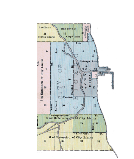
There were several events that lead to even further expansion of the city. The first was the Republican Natonal Convention held in 1860, which caused an immediate need for a public hall to be built. Another was the coming of the Civil War. Sixty acres of land that was formerly owned by Stephen A. Douglas was converted to a prison camp for captured Confederates in 1862 and was one of four such camps in Northern Illinois. The camp, appropriately named Camp Douglas, was located south of 31st Street and Cottage Grove Avenue. Still another was the announcement that Chicago was declared a Port of Entry. The first for an inland city.
|
Ward
|
Division |
North
|
South
|
East
|
West
|
|
1st
|
South |
Chicago River
|
Monroe St
|
Lake Michigan
|
Chicago River
|
|
2nd
|
South |
Monroe St
|
Harrison St
|
Lake Michigan
|
Chicago River
|
|
3rd
|
South |
Harrison St
|
16th St
|
Lake Michigan
|
Chicago River
|
|
4th
|
South |
16th St
|
Egan Ave
|
Lake Michigan
|
Clark St
|
|
5th
|
South |
16th St & River
|
Egan Ave
|
Clark St
|
Western Ave
|
|
6th
|
West |
Van Buren St
|
Chicago River
|
Chicago River
|
Jefferson St
|
|
7th
|
West |
Van Buren St
|
Chicago River
|
Jefferson St
|
Morgan St
|
|
8th
|
West |
Van Buren St
|
Chicago River
|
Morgan St
|
Western Ave
|
|
9th
|
West |
Ohio St
|
Van Buren St
|
Curtis St
|
Western St
|
|
10th
|
West |
Randolph St
|
Van Buren St
|
Chicago River
|
Curtis St
|
|
11th
|
West |
Ohio St
|
Randolph St
|
Chicago River
|
Curtis St
|
|
12th
|
West |
Fullerton Ave
|
Ohio St
|
Chicago River
|
Western Ave
|
|
13th
|
North |
Fullerton Ave
|
North Ave
|
Lake Michigan
|
Chicago River
|
|
14th
|
North |
North Ave
|
Division St
|
Lake Michigan
|
Chicago River
|
|
15th
|
North |
Division St
|
Huron St
|
Lake Michigan
|
Chicago River
|
|
16th
|
North |
Huron St
|
Chicago River
|
Lake Michigan
|
Chicago River
|
Notes: Bold indicates city limits. Egan Avenue (39th St) is now Pershing.