chicagology

  • Contents
  • About
  • Guest Book
  • Bibliography
  • Contact
  • Legal
  • Site Map

Ward Map – 12 February 1853


Population | 1837  | 1847  | 1853  | 1863 | 1869 | 1876 | Map |


The city was approaching 100,000 people and more area was needed for housing and industry.


Ward
Division
North
South
East
West
1st
South
Chicago River
31st St
Lake Michigan
State St
2nd
South
Chicago River
31st St
State St
Clark St
3rd
South
Chicago River
31st St
Clark St
Wells St
4th
South
Chicago River
31st St
Wells St
Chicago River
5th
West
Randolph St
Harrison St
Chicago River
Western Ave
6th
West
North Ave
Randolph St
Chicago River
Western Ave
7th
North
Fullerton Ave
Chicago River
La Salle St
Chicago River
8th
North
Lake Michigan
Chicago River
Wolcott St
La Salle St
9th
North
Lake Michigan
Chicago River
Lake Michigan
Wolcott St
10th
West
Harrison St
Chicago River
Chicago River
Western Ave

Notes: 
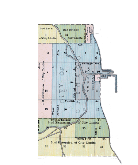
Bold indicates city limits. The 7th Ward extended north to Fullerton between Sedgwick and LaSalle Streets. North of the Chicago River, State Street was named Wolcott Street.


map


Chicagology created March 17, 2003 · Copyright © 2022 · Enterprise Pro Theme on Genesis Framework · WordPress · Log in