Chicago Magazine, August, 1857
THE ILLINOIS AND MICHIGAN CANAL.
As we now look forward to the future in the extension of population and improvements into the now uninhabited, or but sparsely populated territories of the whole West, whether north or south; and as we study the topography of the country, note the situation of the lakes, the large streams which are navigable or may be made so, and along which business and population will flow into regions uninhabited; and where we see connections between great natural points can be made by the least outlay and effort, and natural means of communication be extended; we very naturally imagine the sites here and there where the great cities of the hereafter will be built up; where canals will be made which will connect the waters of the lakes of the north with the great rivers of the south. We can imagine also in generations yet to come, in the periods of decades and centuries, that the whole country will be filled up with a population as dense as that of Illinois, Ohio or New York; and we see where great marts of trade and inland communities, sustained by agricultural resources, will spring up;—where population will gradually sweep away the forests and drain its low lands, covering over the country with improved farms and villages. We see the unexplored streams, in which steamers will ply, and the points along these rivers, the lakes, or the canals to be made as connecting links, where wharfs shall be erected, and an immense business will be conducted by the future people, in the development of the great resources of the country in lumber, in its mines, in its coal, and in agriculture, sustaining other great interests, in mechanics and commerce, and inland trade. None can imagine what such a future will be, only as we can see it foreshadowed by the progress of the country in the past generation. And in that future, not far distant, we shall see that Chicago is no longer the West—it is a central city—and stands to great States, and a larger part of a great nation, west and north west of us, as New York, and Philadelphia, and Cincinnati, now are to the country thus far progressed, lying west of them. As we look upon the map, and mark the position of the mountains, and trace the course of the rivers, catch with the eye the natural points against which population, with its business, must throw its tide, we shall see where great cities are yet to be founded, as our fathers, thirty and fifty years ago, saw the future Buffalo, Detroit, Cincinnati and Chicago. At the west point of Lake Superior we locate some great city of the future, which as a center point of trade between the country of the North-West and the navigation upon the lake, with lumber, mines and fisheries, will come up of necessity. We see that a narrow strip of land, at the height of the flow of waters, is only to be severed by an artificial channel, as that between Lake Michigan and the Illinois River, and navigation is established between Lake Superior and the Mississippi. Who can doubt but that in time this communication will be made. Already is a track of a railroad projected. We look farther back into the interior—we see the land dotted with lakes, connected by rivers, which are natural channels of communication, some of which flow north into lakes in an almost, to us, unknown land; and flowing still further, empty into Hudson’s Bay. Though we have but little communication with this section, and know but little about it, so far is it removed from the circle of our sympathies, yet we shall find along the course of this Red River, settlements of white men, and a single town containing a population of white and mixed blood of six thousand inhabitants. Up the channel of the Mississippi, and of the Missouri, reaching far now into uninhabited regions—up the channel of the Nebraska and the Kansas, are foreshadowed homes, villages, towns, and cities, which are to be—and they will spring up as the generation past have thronged upon the course of the Ohio, the Wabash, the Maumee, the Illinois, and many other of the noble streams of the West. Who can foretell the destiny of this country? who can comprehend its future, and number its population, and draw the picture of it as it shall be in the more perfect ages to come? when all this New World shall have become Old, and abound in relics of antiquity, even as the nations of the eastern continent are old in this age of the world!
Forty years ago the people of the Atlantic States, exulting in great prosperity, and in high hopes of an increase of population, and of extension of improvements into the West, had some such vague notions of the country around the head of Lake Michigan, as we have of the lands high up the Missouri, or about Lake Winnepeg, or Lake of the Woods. But they never imagined any such strides of population to the Far West, as have been made-coming here, and passing on many hundreds of miles beyond us in every direction. That which has taken place in the progress of settlement, should have been the work of ages, according to their comprehension of things. We find that as long ago as seventy years, the North-West Territory was marked off prospectively into States; with a wise view to the speedy settlement of the country known as the North-West. Further than this there was little expectation, and it was believed that the interior was a country sealed up by God for ages yet to come. After the commencement of this century, the improvement of the national territories attracted considerable attention. There were able articles written and published on the character of the country, its natural resources, &e. Some schemes of improvement, some expectations as to the sites of its future cities, were discussed and suggested. Important towns would some time grow up upon the shores of the lakes; and at the head of Lake Michigan, as the geography indicated, there would be an important inland city. The navigable branches of the Mississippi stretching North, and to the North-East, seemed struggling for a closer communion, and to invite but a reasonable enlistment of the enterprise of men, to improve their natural channels, and overcome obstacles, and perfect a line of navigation from the Lakes whose waters flow north and east into the Atlantic Ocean, to the Mississippi River, whose waters flow south into the Gulf of Mexico,—outlets that are separated thousands of miles, which drain a continent of land unexampled in fertility, and which flow from the heart of a nation, which has no superior in all the resources which can make a nation, on the globe. Standing at the head of these water courses, in the middle ground between the two, with a hand upon the two regions, and a free choice from which to select, whenever interest or a wise policy may require a selection—will be this central inland city at the head of Lake Michigan. So men of past days could foresee the future.
Frank Leslie’s Illustrated Newspaper, April 30, 1859
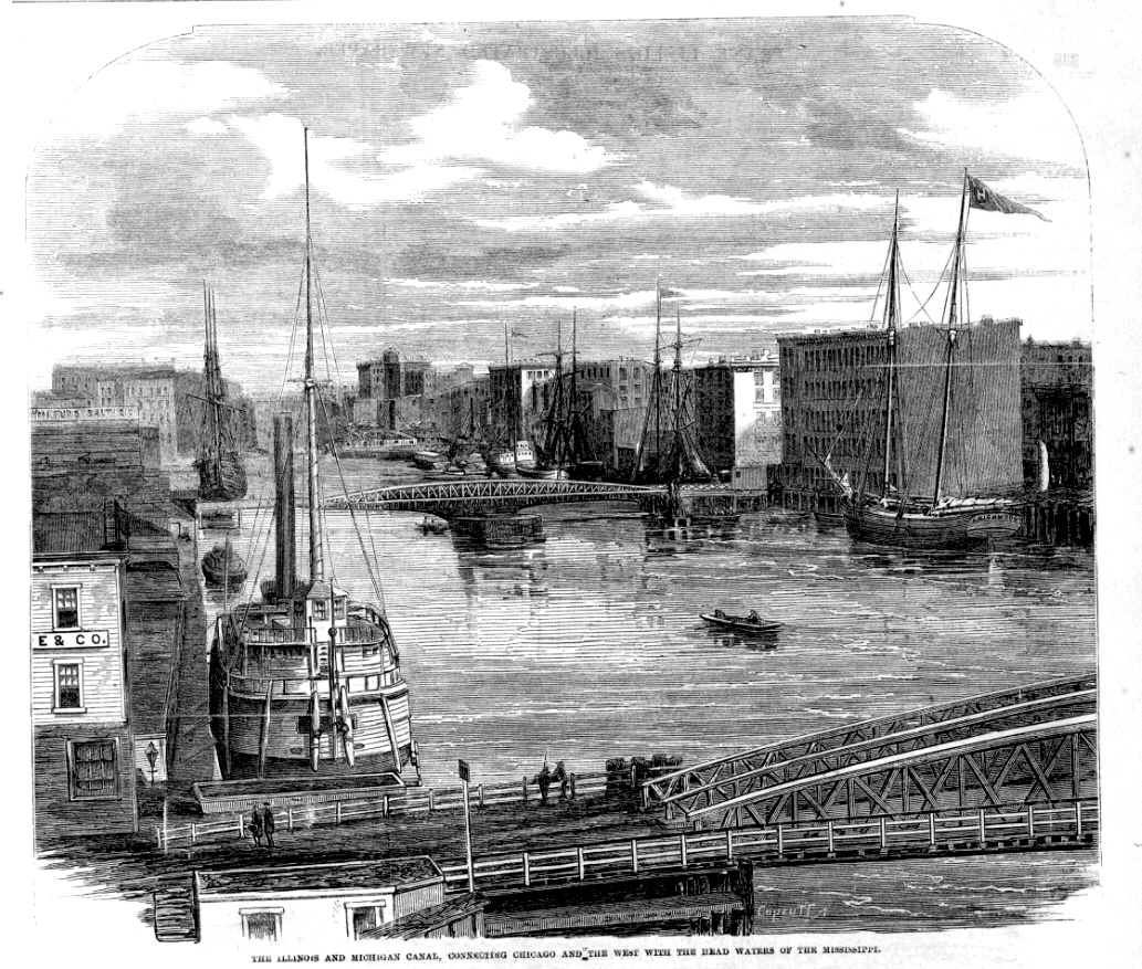
- The Illinois and Michigan Canal, Connecting Chicago and the West with the Head Waters of the Mississippi.
As a matter of course, when the first indications of settlement were manifested, public attention was drawn to the possibility of opening, at some future time, a communication between the Illinois river and the Lake. The route had been followed by the earliest French explorers, and it had been kept up by the future intercourse of the traders with the Indians—because it was a line of travel and navigation which nature had provided to link distant portions of the country together. Therefore, when the Indians first relinquished any title to their lands, it was where this future city should be, and the next extinguishment of title was over a line of territory averaging twenty miles in width, that formed the road-way between the Lake and the River. When it was considered what should be the character of that natural thoroughfare of trade and travel, a canal was most naturally suggested, as the one best adapted to the circumstances and wants of the locality. And the early purpose of making it a “ship canal,” a channel of sufficient capacity to take through it the largest boats adapted to the navigation of the rivers below, and the lakes above—which was laid aside only for the want of means to execute it—was the wisest suggestion that has yet been made, as the proper means of wedding the North with the South, by the conjunction of the navigable interests of the lakes and rivers—and which sooner or later must be adopted.
The first suggestion found in print of this proposed canal, is contained in the sixth volume of Niles Register, page 394, of the date of August 6, 1814, in an article written during the last war with Great Britain, on the importance, in a national point of view, of the States and Territories of the North-west, and of the improvement of the courses of inland navigation.
The passage is as follows:
- By the Illinois river, it is probable that Buffalo, in New York, may be united with New Orleans, by inland navigation, through lakes Erie, Huron and Michigan, and down that river (the Illinois,) to the Mississippi. What a route! How stupendous the idea! How dwindles the importance of the artificial canals of Europe compared with this water communication! If it should ever take place, (and it is said the opening can be easily made,) the territory will become the seat of an immense commerce and a market for the commodities of all regions.
So thought a writer forty-three years ago, who with the map of the country
before him, and the lakes and rivers of the North-west traced thereon, he could foresee what would be the demands of the future, as the men of to-day, with the map of the North-west before them, set reflecting, imagining, theorising and philosophising upon the national growth in the territories now just opening to population, and where it will be necessary to extend navigation by canal, or where the track of the Pacific Railroad should be laid, or where an important city will fill a place on the map of the world, never more to be blotted out.
Therefore, the extinguishment of the Indian title, by the treaty with the Pottawa. tomies in 1816, to the strip of land from Ottawa to Chicago, covering in a breadth of twenty miles wide, the navigable route of the Illinois, Des Plaines, and the portage to the Chicago River, as the foreshadowing preparation for the carrying out of this “stupendous idea,” of opening water communication from the Lake to the River, as a belt to girdle the Union.
Gov. Bond, first Governor of Illinois under the Constitution as a State, in his inaugural address, in 1818, first called the attention of the General Assembly to a survey, preparatory to opening a canal upon this route. He suggested an early application to Congress for a certain percentage of the sale of the public lands in the bounds of the state, to be appropriated for this object. In his valedictory message, in December, 1822, he again referred to the subject, and to its having been suggested in his first address, and stated—” It is believed that the public sentiment has been ascertained in relation to the subject, and that our fellow citizens are prepared to sustain their representatives in the adoption of measures subservient to its commencement.”
The session of Congress for 1821-2 passed an act which gave “permission to the State of Illinois to cut a canal through the public lands, connecting the Illinois River with Lake Michigan, and granting to it the breadth of the canal, and ninety feet on each side of it;” which permission was coupled with the condition, “that the State should permit all articles belonging to the United States, or to any person in their employ, to pass toll free forever.”
Gov. Cole, successor to Gov. Bond, inaugurated in December, 1822, in his inaugural address, devotes four pages to the consideration of the canal and internal improvements of the State. The governor was an earnest advocate of a judicious system of internal improvements. He proposed various plans for the accummulation of funds for the purpose, such as a revenue from taxes on the military bounty lands, fines and forfeitures, &c. He urged the importance of opening a communication with Lake Erie, by the Wabash, through Indiana, and the Maumee in Ohio, as well as communication with our own lake, in our own bounds, and asked the Legislature to invite the co-operation of those States for that purpose. He directly proposed that measures should be taken for the examination and surveys of the rivers and the canal route from the Illinois to the Lake; and to memorialise Congress for a liberal donation of land, for the opening of this line of national intercourse. A general act for the internal navigation of the State was passed; and a memorial to Congress was also adopted. This act, which was passed the first session under Gor. Cole’s administration, and approved Feb. 14th, 1823, provided for a Board of Commissioners, whose duties were “to devise and adopt measures to open a communication, by canal and locks, between the navigable waters of the Illinois River and Lake Michigan; to cause the route to be explored, surveys and levels to be taken, maps and field books to be constructed, and estimates of the costs to be made; and to invite the attention of the governors of the States of Indiana and Ohio, and through them the Legislature of those States, to the importance of a canal communication between the Wabash and the Maumee Rivers.” Thomas Sloo, jr., of Hamilton county, and Theophilus W. Smith, Emanuel J. West, and Erastus Brown, all of Madison county, were elected the said commissioners. In the autumn following, a portion of the commissioners, with Col. Justus Post, of Missouri, oppointed Engineer, made the first exploring tour of the route. In the next autumn after this, in 1824, Col. Rene Paul, of St. Louis, an able engineer, was also employed, and with a necessary corps of men, to assist in the surveys and taking the levels, and accompanied by one commis-sioner, attempted to complete the proposed survey. The party was divided into two companies, and five different routes were surveyed, and an estimate made on each. The plan of construction was on the scale of the New York and Erie Canal. The cost of each route was estimated—the highest being $716,110; the lowest, $639,946. At the next session of the Legislature, an act was passed, dated January 17, 1825, to “in-corporate the Illinois and Michigan Canal Company.” The capital stock was made one million of dollars, in ten thousand shares of one hundred dollars each. The stock not having been taken, this charter was subsequently repealed. Owing to the embarrassed condition of the State, nothing further was attempted for the canal till the Legislature, in 1829, passed an act authorising another Canal Board of Commissioners, consisting of Dr. Jayne, of Springfield, Edward Roberts, of Kaskaskia, and Charles Dunn, with power to employ agents, engineers, surveyors, draftsmen, and other persons, to explore, examine, and determine the route of the canal; also to lay off town sites, sell lots, and apply the funds to the purposes of the canal. This Board was elected to act under the new phase of the enterprise, which it had assumed under an act of Congress, granting land for the construction of the canal. During the time the State was thus taking its first steps to open this canal, Daniel P. Cook, from whom Cook county was named, was the Representative in Congress, and he, in conjunction with the U. S. Senators, Jesse B. Thomas and Ninian Edwards, (and Elias K, Kane after 1825,) were active in their efforts to procure an appropriation from Congress. To Daniel P. Cook, however, we believe it is no more than justice to say, are we chiefly indebted for getting the appropriation of land through Congress. As the result of these efforts, an act was passed by Congress March 2, 1827, granting to the State of Illinois, for the construction of this work, each alternate section of land, five miles in width, on each side of the proposed canal. From this act of Congress did the State acquire the title to those lands which have filled so important a part in the financial operations of the State—which have aided so essentially the completion of this work, so important to our city, the State and the nation—from which the titles have come for these valuable canal lands, on which so large a portion of our city is built, on which have sprung up villages all along its line, and from which the owners of so many farms, now flourishing, derived their title.
After the State had first moved in behalf of this measure, having had the subject called up by its first two governors, it became also a matter, to a considerable extent, of national concernment. Information in regard to the practicability of the route, its effect upon the improvement of the country, and its connection also with the growth of Chicago, which was then but a village, as will be noticed from our report of its progress thus far, were matters inquired into by public men everywhere; and whoever had the opportunity of making any personal examination into these matters failed not to do so. At the time this enterprise was proposed, population had not extended above the middle portion of the State. Sangamo River and Fulton County embracing all west of the Illinois River, were the northern boundaries of the settlements in the State. Chicago was only the same trading village it had been for nearly twenty years previously. Peoria was but the site of a dozen French families, and Springfield, now capital of the State, was the frontier village on the north, having not more than a dozen log cabins. Morgan county, the upper county east of the Illinois, including what is now Cass and Scott counties, had altogether about seventy-five families. The northern part of the State, where we have now the heaviest portion of the population and the greatest amount of public spirit, was then a wilderness, an uninhabitable prairie, which, as it was supposed, an age would be required to overcome. Like many whom we have seen, generally intelligent men, who have calculated that our large prairies would remain uninhabitable for a hundred years, they supposed the Grand Prairie traversed hy the Illinois Central Railroad would remain for many generations like a desert, to divide the interests of the State. Just before the commissioners appointed by the Legislature had made their first examination of the canal route, the Expedition under Major Long, for the exploration of the source of the St. Peter’s River, &c., passed through Chicago, on their way, in June, 1823. The party remained a few days at Fort Wayne, thence they proceeded to Chicago, and after stopping here for an examination of the post and of the country around, they continued on their way, through the north part of the State, to the Mississippi, at the Dubuque lead mines, the whole route through from Fort Wayne being as much of a wilderness as if never before explored by white men. Prof. Keating, who is the author of the “Narrative of the Expedition,” gives us the following description of Chicago, (then known as Fort Dearborn,) as it appeared when visited by the party in June, 1823:
- Fort Dearborn is situated in the State of Illinois, on the south bank, and near to the mouth of the Chicago river; the boundary line between this State and that of Indiana strikes the Western shore of Lake Michigan ten miles north of its southernmost extremity, and then continues along the shore of the lake until it reaches the forty-second and a half degree of north latitude, along which it extends to the Mississippi. The post at Chicago was abandoned a few months after the party visited it. Its establishment had been found necessary to intimidate the hostile and still very powerful tribes of Indians that inhabit this part of the country; but the rapid extension of the white population to the west, the establishment along the Mississippi river of a chain of military posts which encloses them, and at the same time convinces them of the vigilance of the government, and of the inevitable destruction which they would bring upon themselves by the most trifling act of hostility on their part, have, it is thought, rendered the continuance of a military force at this place unnecessary. An Indian agent remains there, in order to keep up amicable relatious with them, and to attend to their wants, which are daily becoming greater, owing to the increasing scareity of game in the country.
We were much disappointed at the appearance of Chicago and its vicinity. We found in it nothing to justify the great eulogium lavished upon this place by a late traveler, who observes that ‘it is the most fertile and beautiful that can be imagined.’ ‘As a farming country,’ says he, ‘it unites the fertile soil of the finest lowland prairies with an elevation which exempts it from the influence of stagnant waters, and a summer climate of delightful serenity.1 The best comment upon this description of the climate and soil is the fact that, with the most active vigilance on the part of the officers, it was impossible for the garrison, consisting of from seventy to ninety men, to subsist themselves upon the grain raised in the country, although much of their time was devoted to agricultural pursuits. The difficulties which the agriculturist meets with here are enormous; they arise from the shallowness of the soil, from its humidity, and from its exposure to the cold and damp winds which blow from the lake with great force during most part of the year; the grain is frequently destroyed by swarms of in-sects; there are also a number of destructive birds of which it was impossible for the garrison to avoid the baneful influence, except by keeping, as was practiced at Fort Dearborn, a party of soldiers constantly engaged at shooting at the crows and blackbirds that depredated upon the corn planted by them. But, even with all these exertions, the maize seldom has time to ripen, owing to the shortness and coldness of the season. The provisions for the garrison were for the most part conveyed from Mackinaw in a schooner, and sometimes they were brought from St. Louis, a distance of three hundred and eighty-six miles, up the Illinois and Des Plaines rivers.
The appearance of the country near Chicago offers but few features upon which the eye of the traveler can dwell with pleasure. There is too much uniformity in the scenery; the extensive water prospect is a waste uncheckered by islands, unenlivened by the spreading canvass, and the fatiguing monotony of which is increased by the equally undiversified prospect of the land scenery, which affords no relief to the sight, as it consists merely of a plain in which but few patches of thin and scrubby woods are observed scattered here and there.
The village presents no cheering prospect, as, notwithstanding its antiquity, it consists of but few huts, inhabited by a miserable race of men, scarcely equal to the Indians from whom they are descended. Their log or bark houses are low, filthy and dis-gusting, displaying not the least trace of comfort. Chicago is perhaps one of the oldest settlements in the Indian country; its name, derived from the Pottawatomie language, signifies either a skunk, or a wild onion; and either of these significations has been occasionally given for it. A fort is said to have formerly existed there. Mention is made of the place as having been visited in 1671 by Perot, who found “Chicagou” to be the residence of a powerful chief of the Miamis. The number of trails centering all at this spot, and their apparent antiquity, indicate that this was probably for a long while the site of a large Indian village. As a place of business, it offers no inducement to the settler; for the whole annual amount of the trade on the lake did not exceed the cargo of five or six schooners even at the time when the garrison received its supplies from Mackinaw. It is not impossible that at some distant day, when the banks of the Illinois shall have been covered with a dense population, and when the low prai-
ries which extend between that river and Fort Wayne, shall have acquired a population proportionate to the produce which they can yield, that Chicago may become one of the points in the direct line of communication between the northern lakes and the Mississippi; but even the intercourse which will be carried on through this communication, will, we thínk, at all times be a limited one; the dangers attending the navigation of the lake, and the scarcity of harbors along the shore, must ever prove a serious obstacle to the increase of the commercial importance of Chicago. The extent of the sand banks which are formed on the eastern and southern shore, by the prevailing north and north-westerly winds, will likewise prevent any important works from being undertaken to improve the post of Chicago.2
Thus commented, thirty-four years ago, the author of a narrative of an official exploring party, sent out by order of government to make report on the character of the country over which they were to pass—-thus testing by competent and scientific men the condition and resources for settlement of a new country. This, no doubt, was a truthful representation of things, as they then appeared—but then how little was the importance of the West understood, and the place it was destined to fill in the history of the country! “It is not impossible,” they say, ” that at some distant day (thirty-four years,) when the Illinois shall have been covered with a dense population, &c., Chicago may become one of the points in a direct line of communication…. which always must be a limited one;… and the scarcity of harbors must prove a serious obstacle to the increase of the commercial importance of Chicago,”—which in thirty-four years has a population of one hundred and ten thousand, and has become the largest grain market, and also the largest lumber market in the world.
This subject matter of a “direct communication between the Northern Lakes and the Mississippi,” which had been broached in other quarters, was one which this exploring party felt authorised to look into; they therefore made an examination of the water-shed, or the line at the “summit level” of the great national water flow that divides the elements of a summer shower, so that kindred drops shall be separated, some to flow south through the Des Plaines, Illinois, and’Mississippi, out into t’re Gulf of Mexico; others to flow north, through Lake Michigan, and the other lakes, over the Cataract of Niagara, through the River St. Lawrence, into the Atlantic, there to be joined, under the cold glance of the icebergs, by the kindred drops that had flowed south to water the orange groves and cane fields, and wafted together again, by the course of the Gulf Stream, like long severed friends, to meet once more. The account there given of the high water channel that connects the two sections, and which had sometimes been used for the purposes of navigation, will be read with interest now, while the subject of the improvement of the Illinois River, by a supply of water fiom the lake, through a ship canal, is again being agitated, and with more practical views of its feasibility, and its value as an improvement, and of the effect it may have on the navigation of the Illinois, the prosperity of the country, and the business and health of Chicago. Says the Narrative,—
“The south fork of Chicago river takes its rise about six miles from the fort, in a swamp which communicates also with the Des Plaines, one of the head branches of the Illinois. Having been informed that this route was frequently traveled by traders, and that it had been used by one of the officers of the garrison, who returned with provisions from St. Louis a few days before our arrival at the fort, we determined to ascend the Chicago river in order to observe this interesting division of waters. We accordingly left the fort on the 7th of June, in a boat which, after having ascended the river about four miles, we exchanged for a narrow pirogue that drew less water; the stream we were ascending was very narrow, rapid, and crooked, presenting a great fall; it continued so for about three miles, when we reached a sort of swamp designated by the
Canadian voyagers under the name of le petit lac.3 Our course through this swamp, which extended for three miles, was very much impeded by the high grass, weeds, &e. through which our pirogue passed with difficulty. Observing that our progress through the fen was very slow, and the day being considerably advanced, we landed on the north bank, and continued our course along the edge of the swamp for about three miles, until we reached the place where the old Portage road meets the current, which was here very distinct towards the south. We were delighted at beholding for the first time, a feature so interesting in itself, but which afterwards we had an opportunity of observing frequently on the route; viz: the division of waters starting from the same source, and running in two different directions, so as to become the feeders of streams that discharge themselves into the ocean an immense distance apart. Although at the time we visited it, there was scarcely water enough to permit our pirogue to pass, we could not doubt that in the spring of the year the route must be a very eligible one.— Lieut. Hopson, who accompanied us to the Des Plaines, told us that he had traveled it with ease, in a boat loaded with lead and flour. The distance from the fort to the intersection of the Portage road and the Des Plaines, is supposed to be about twelve or thirteen miles; the elevation of the feeding lake above Chicago river is estimated at five or six feet; and it is probable that the descent to the Des Plaines is less consider-able. The Portage road is about eleven miles long; the usual distance traveled by land seldom, however, exceeds from four to nine miles; in very dry seasons it has been said to amount to thirty miles, as the Portage then extends to Mount Juliet, near the confluence of the Kankakee. When we consider the facts above stated, we are irresistably led to the conclusion, that an elevation of the lakes of a few feet, (not exceeding ten or twelve,) above their present level, would cause them to discharge their wa-ters, partly, at least, into the Gulf of Mexico; that such a discharge has at one time existed, every one conversant with the nature of the country must admit; and it is equally apparent that an expenditure, trifling in comparison to the importance of the object, would again render Lake Michigan a tributary of the Mexican Gulf. Impressed with the importance of this object, the legislature of Illinois has already caused some observations to be made upon the possibility of establishing this communication; the commissioners appointed to that effect, visited Chicago after we left it, and we know not what results they obtained, as their report has not reached us; but we have been informed that they had considered the elevation of the petit lac above Chicago to be somewhat greater than we had estimated it. It is the opinion of those best acquainted with the nature of the country, that the easiest communication would be between the little Calamick and some point of the Des Plaines, probably below the Portage road; between these two points, there is in wet seasons, we understand, a water communication of ten or twelve miles. Of the practicability of the work, and of the sufficiency of a supply of water no doubt can exist. The only difficulty will, we apprehend, be in keeping the communication open after it is once made, as the soil is swampy, and probably will require particular care to oppose the return of the soft mud into the excavations.”4
The canal commissioners appointed under the act of January, 1829, proceeded to make somewhat available the lands donated for the purpose, by laying out the towns along the line of the canal—first laying out the town of Ottawa, at the junction of the Fox River with the Illinois—and in the autumn of 1829, authorised the laying out of the town of Chicago, on the alternate section which belonged in course to the canal lands—which lay upon the main channel of the river, and over the junction of the two Branches-having employed Mr. James Thompson to survey and plat the town, which he did. His first map is in the Recorder’s office, bearing date August 4th, 1830, and is
the part known as the original town of Chicago—which was the first beginning of Chicago as a recognised place, having a locality and a name among the towns and cities of the earth-the first official act of organization, which must be dated as its birth. And so this city, of more than a hundred thousand inhabitants, will have arrived this month of August, at the ripe youthful age of twenty-seven years.
The projection of the Illinois and Michigan Canal was the immediate precursor of Chicago, the source from which she received her first impulse, and is that enterprise to which Chicago is more indebted to-day for her greatness than to any other source. It is true that she has felt a more direct and speedy impulse from her many railroads; but the canal was her strength in her infancy, her hope for many long years of struggling to keep her place, when her fortunes, with that of the canal, waxed and waned together—when financial disasters fell upon one, it fell upon the other; and at last, when the canal policy prevailed and its fortunes rose, Chicago rose with it; and when it triumphed at last, and the work was finished, Chicago triumphed also, and became then the full formed bud of promise-of all that she has been since. Then her railroads became a necessity demanded by her next step of progress, and they, too, lingered and struggled for a time; but as Chicago, backed by the country, had made the canal, she also made her railroads. But she has outgrown her nursing mother, and the canal is now looked upon as an old fogy institution—one of the things that were, to be superceded by new inventions; but, nevertheless, she has her old-fashioned uses, and Chicago knows better than to give up her canal. She and the State must make another move with it, or it will be truly a thing behind the times—and that is, to enlarge it to the original conception of a ship canal, to draw off, through the harbor of Chicago, the drainage of the city in the supply of water needed for the improvement of the Illinois River; or in some way so modifying the original plan, that a complete line of steamboat navigation shall be opened from the river to the lake, so that we shall find among the things that have soon come to pass, the steamers from New Orleans lying moored at our docks. Nothing short of this will answer the demands of the times.
The Canal Commissioners having thus stuck their first stakes, in providing for towns at each end of their line, they found it necessary again to revise their surveys. The plan of finishing it on the dimensions of the New York canal, and of obtaining a supply of water on the surface level from the Des Plaines as the first feeder, was very doubtful: and the rock on the summit level appearing so near the surface, it being necessary to make a deep cut through the rock to obtain the water from the lake, the largely increased estimate of cost threw doubt and discouragement upon the whole plan. The subject, before anything could be done, went back to the next legislature, who authorized a re-examination, and whether a supply of water could be obtained from Calumet as a feeder, and the estimation of the costs upon a larger plan of taking the water from the lake as a ship canal; and in the same connection, the act authorised an examination into the cost of a single track railway, as a substitute for the canal. Much discussion with the public followed the introduction of this railway project, a large part being in favor of dropping the canal altogether for the railroad; and thus public attention, and the actual support and countenance wanted for one, was for a time divided between the two projects. The cost of the railroad, ninety-five miles, was estimated at about a million of dollars, and there are those who believe now that it would have been better for the State had the railroad been adopted in lieu of the canal. But as it is, we have the canal, and now a railroad also, nearly following the line of its course—and there is room to doubt, if enterprise had not conquered on the canal effort, if we should have had the railroads. Progress usually follows its own order naturally.
NOTES:
1Schoolcraft’s Narative Journal of Travels, (Albany, 1820.) page 284
2Major Long’s Expedition, pages 162-65.
3Mud Lake, as it has since been called by the early settlers.
4Major Long’s Expedition, pages 165-67.
Leave a Reply