Chicago Tribune, May 13, 1900
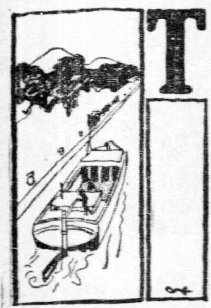 HE site of chief historic interest in the Fifth Ward is one which recalls terrible memories.
The great Illinois and Michigan Canal, the story of which belongs to the Sixth Ward, had been formally opened but a year when, in 1849, the dread epidemic of Asiatic cholera struck the city. In anticipation of its arrival the city authorities had erected in La Salle street, between Eighteenth and Nineteenth streets, a cholera hospital, which stood until burned by the city in 1852. Afterwards in 1855 a new and permanent hospital was erected on the same site at a cost of $45,000.
The first building was the center of excitement during the great epidemic of 1849. So virulent was the the plague that within a month that summer more than 1,000 people were attacked by it, of whom more than 300 died. Men in the fullness of their strength would be at their work one day and lying dead the next. Other diseases raged at the same time, and in July, 1849, the total deaths reported were 931.
For some years thereafter the city enjoyed almost complete immunity from the plague. In 1854, however, before the new hospital building was built, it broke out again with redoubled violence. For a period the deaths averaged sixty a day and the city became almost depopulated, those who were not seized hurrying away to Milwaukee and other cities. Altogether there were nearly 1,500 deaths from the cholera in Chicago during that year.
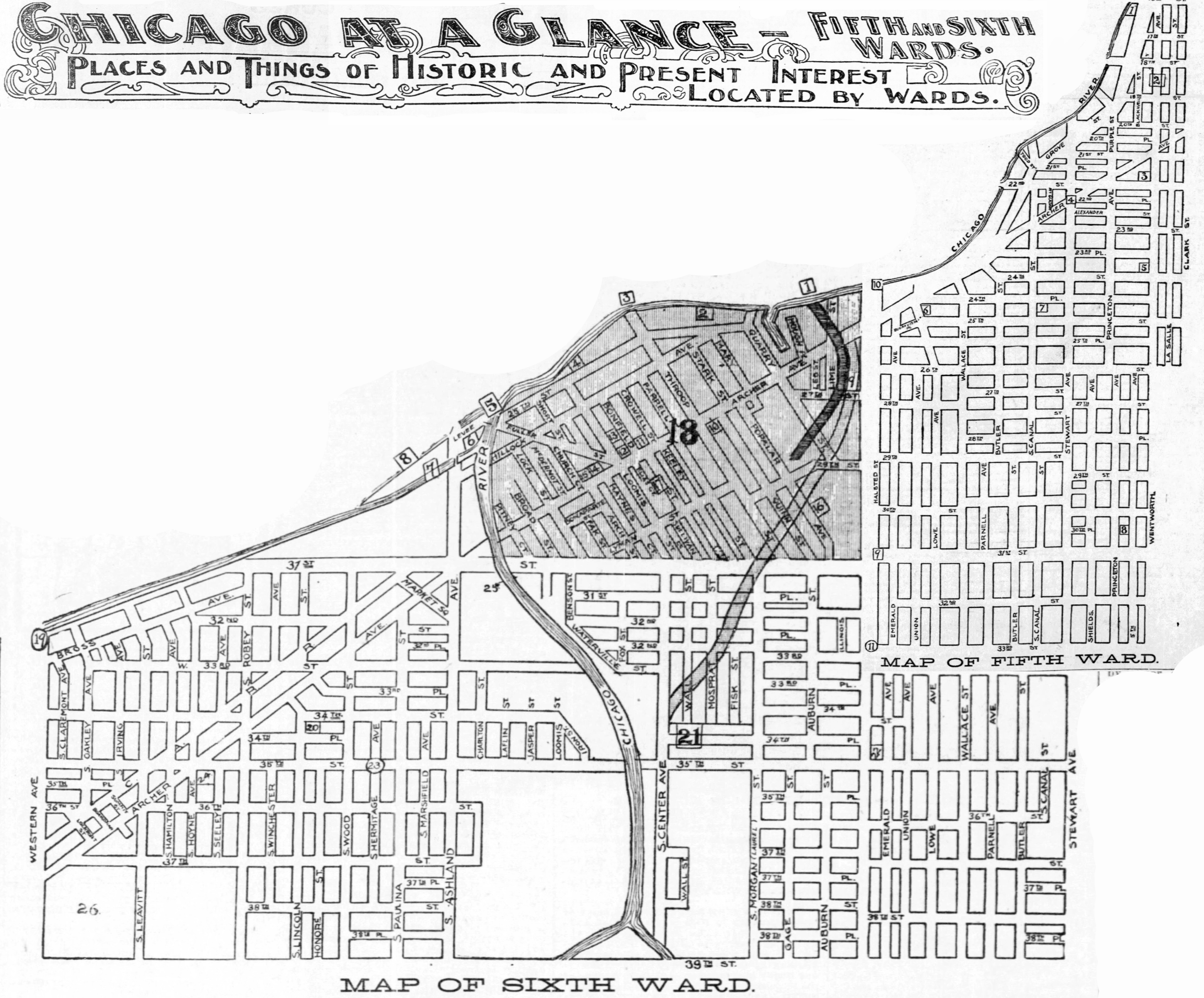
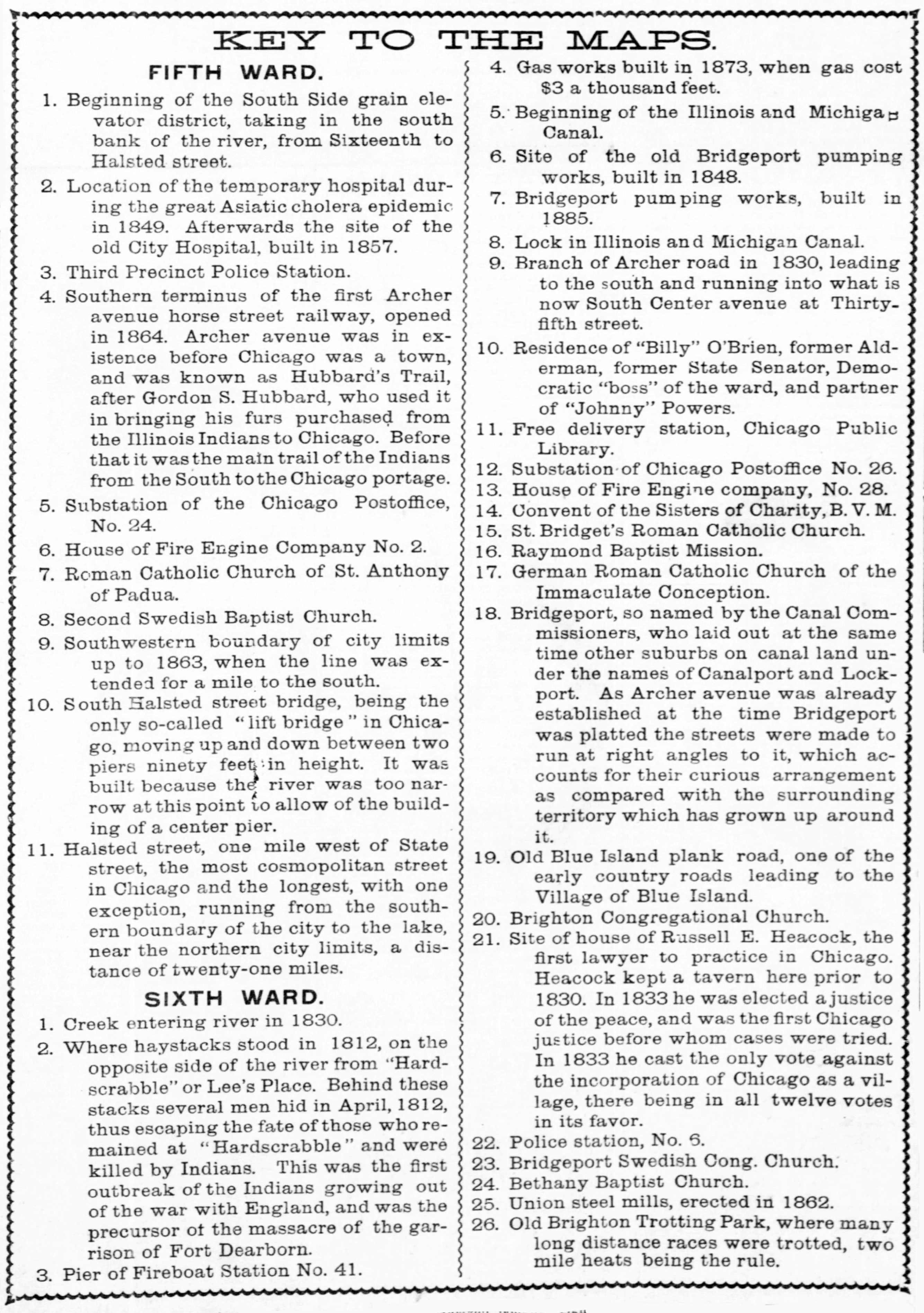
To turn to the Sixth Ward and to a pleasanter subject, it is to be recorded that within the limits of the present Sixth Ward prior to 1830 the first lawyer to settle in Chicago. His name was Russell E. Heacock and he had a cabin near what is now the corner of Thirty-fifth street and South Center avenue. Heacock was, however, more than a lawyer. He was a good carpenter as well, and in addition kept tavern at his cabin, which was a convenient stopping place for traders and others on their way to and from Chicago. Heacock was also one of the first men elected justice of the peace in the county, so that the Sixth Ward may justly claim as its own the residence of the man who was at the same time the pioneer and founder of the bench and bar of Chicago.
In the Sixth Ward, also, lies historic Bridgeport and the site of the famous old Brighton Trotting Park, where were trottered many of the then popular long distance races. In 1856 spectators were called to the Brighton Park by the announcement of a fight to the death between a bear and a buffalo. There were also races between Indian runners and on one occasion a great race between a bear and a horse.
There is still another spot in the Sixth Ward the sight of which carries the memory of back to the Indian massacre of 1812.
On April 7, 1812, a row of ricks of prairies hay stood on the spot marked ⑩ on the Sixth Ward map. It was the property of Lee, who then lived in Hardscrabble, across the river. That evening some Indians went to Lee’s place. There were four men in the cabin at the time. They were the son of Lee, a boy, a discharged soldier, a Frenchman, named Debou; and a man named Liberty White. The ex-soldier did not like the manner of the Indians and told Lee’s boy of his suspicions. He and the boy left the cabin, saying to the Indians they must cross the river and take some hay from the stacks for the cattle. They went across the little stream and pretended to be busy getting down the hay, until they saw an opportunity, when they ran; as they did they heard shots fired in the cabin. They made their way through the woods along the river bank till they came opposite the house of John Burns, which stood then at what is now North Water and Clark streets, where they gave the alarm.
Debou and White were murdered. This was the first crime committed by the Indians as a result of their alliance with the British, which led to the Fort Dearborn massacre, four months later.
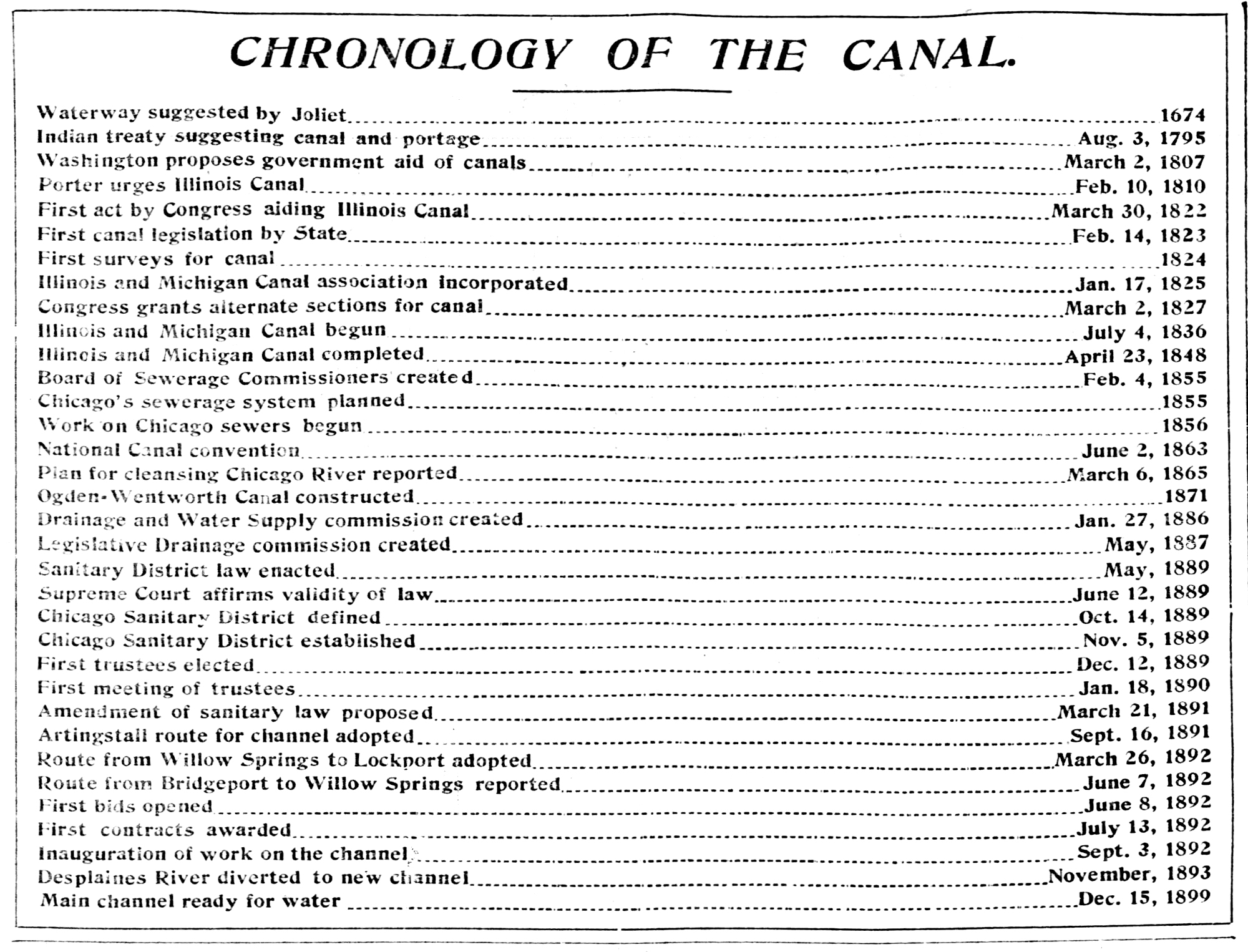
THE FIRST CANAL.
But the Sixth Ward has still another claim to historic importance. In it are to be found the traces of Chicago’s real reason for being great. Other things were essential, but by arguing it backwards it is easy to conclude that if a certain ditch which has one end in the Sixth Ward and which is now rapidly falling into oblivion had never been dug, the rapid growth of Chicago would have been delayed for years and the city might have been permanently blighted. At this time it is not easy to appreciate what significance the ditch known as the Illinois and Michigan Canal possessed in its day. It is fair to assume that few people, even residents of the Sixth Ward, have the faintest idea of the bulk of history that ditch has been the means of creating.
Nowadays it is a senseless custom to laugh at the name of Bridgeport. There was a time, however, when its place on the map of Illinois was marked with a str. It was the pleasant meadow land that stretched its verdure under the eye of Father Marquette, whose cabinage, in 1763, was just across the river. It was the grassy plain that provided the hayfield for the settlers of Hardscrabble, over in what is now the Eight Ward. It was where the first blast furnace in Chicago was built in 1859 and it was the important way station on Archer road between Chicago and Lockport.
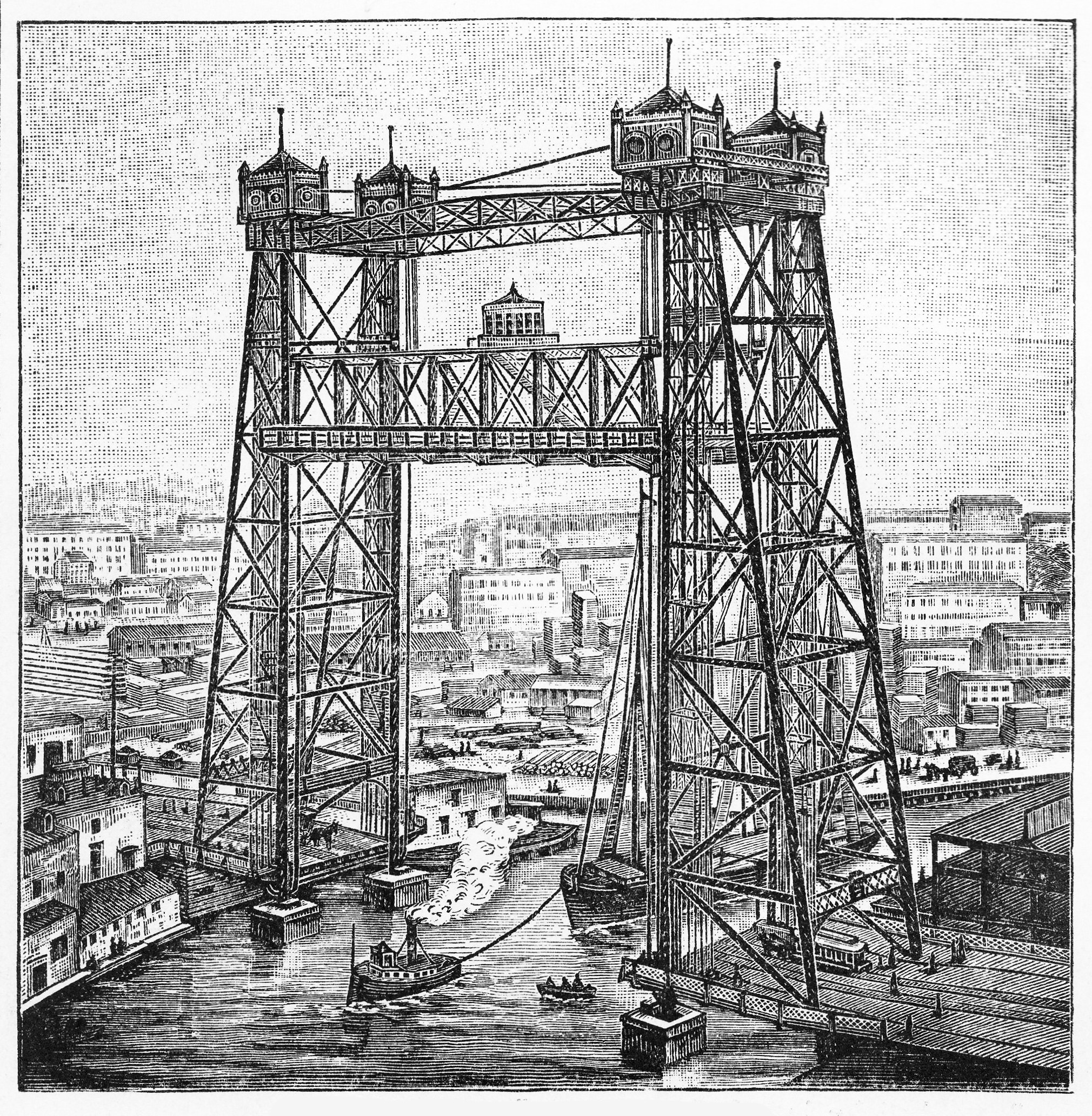
- Halsted Street Lift Bridge #3
1893
Bridgeport, which is inclosed in the Sixth Ward, with Halsted and Thirty-first. Ashland avenue and the river for its boundaries, was the village that grew up around the terminus of the portentous Illinois and Michigan Canal. The rolling mill and the elevators have long since taken on more importance in Bridgeport than the murky canal, but if each were measured in its day, the elevators and the rolling mills would seem as trifles compared with the canal. Even the towering castellated lift bridge in Halsted street, which forms a sort of medieval gateway of Bridgeport, takes more plumes to itself now than the sleepy old canal with only the occasional wheezing of a stone barge to wake it from slumber.
The great highway of the Fifth and Sixth Wards, Archer avenue, has a history intertwined in that of the canal. It would not have been built if the cause of the canal did not need it. There was talk of jobbery at the time of construction, and that it gave additional interest. Colonel Archer, who was prominent enough in canal affairs as a commissioner to have the road built in 1835 and to name it after him, was accused of having it constructed for the benefit of his property in Lockport. The road ran from its present intersection with State street to Lockport, which was more important than Chicago then. It cost $40,000 and would never have been built if it were argued the road was necessary to the construction of the canal.
To tell the story of this ditch, whose history leads a sort of romance with the exploration of the Chicago, Desplaines, and Illinois Rivers in 1673 by Father Marquette and his companions. In the writings of Gather Claudius Dablon, a French Jesuit missionary in Canada, he relates correspondence with Joliet in which that observing voyageur called attention to the advantage that would arise from the digging of a canal that would connect the Chicago and Desplaines Rivers and furnish a waterway between the lakes and the gulf.
After a century and a half the suggestion of Joliet became an inspiration to action. In 1816 a treaty with the Pottawatomie Indians was effected at St. Louis. By the terms of that treaty the Indians ceded a strip of land extending from Ottawa to Chicago and twenty miles in width. This cession was ontained for the purpose of building a canal from Chicago to Ottawa. Major S. H. Long, a United States engineer, went over the route in that year and suggested the course the canal might best follow. That was the first practical step taken to make the waterway a reality.
CANAL MADE CHICAGO.
Chicago was then only a military post with an Indian agency attached to it. It didn’t have enough taxable property to furnish means to support a lock tender, much less build a canal. When the preliminaries to the building of the canal did come about, Chicago immediately leaped into existence as a village. The first part of Chicago was made by the Canal Commissioners; the first sale of lots in Chicago was made by the canal as clearly and as positively as Western towns have been made in recent years and are still being made by the advent of railroads. Chicago was a canal town, just as McCook on the new drainage canal is a canal town.
It was in 1830 that Chicago was made by the Illinois and Michigan Canal, fourteen years after the first preliminary survey. After the Indians had ceded the land to the government it was necessary that leave of Congress be obtained for the cutting of the canal. This was granted by an act passed in 1822. That act gave the State permission to dig the canal and as incentive to the State to do it, was given ninety feet on each side of the proposed canal for its whole length. Congress also appropriated $10,000 to pay for the survey of the way.
Commissioners were appointed in 1823 to survey the route. They were Thomas Sloo Jr., Theopholis W. Smith, Emanuel J. West, Erastus Brown, and Samuel Alexander. Nothing of any account was done until 1825, when the Illinois and Michigan Canal company was incorporated with a capital of $1,000,000 for the purpose of building the canal. The working company was organized, but did nothing, and the next year the law was repealed, Congress was again asked for a canal and petitioned it a liberal one. In 1827 Congress passed another law granting to the State of Illinois the alternate sections on both sides of the route to help pay for the ditch. This grant amounted to 284,000 acres.
The grant of so much land by Congress for that purpose attracted attention seriously to the Northwest as having commercial possibilities. Chicago was beginning to be something more than a military post.
In 1828 another act of Congress was passed which provided for the sale of lots and land grants as the canal subsidy. In 1829 a new set of commissioners was appointed. They were Dr. Jaynes of Springfield, Edmund Roberts of Kaskaskia, and Charles Dunne. These three men may be called the official fathers of Chicago. In 1830, the year following their appointment, they laid out a town at what was to be the lower end of the canal and which is the pretty City of Ottawa today. In the fall of 1830 they reached Chicago. With them was James Thompson, a n engineer. He was directed to lay out a town site, to be called by the name iof Chicago, which was applied to the river by Indians as far back as their traditions ran and which was the name accepted by Father Marquette.
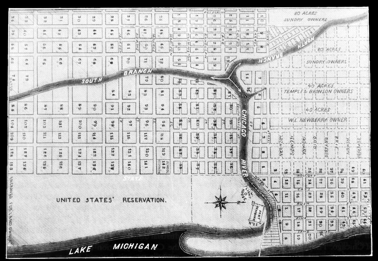
- The original 1830 subdivision by the Illinois and Michigan Canal Commissioners is the area south of Kinzie Street (2 blocks north of the river). Map shows additions by 1835. This map was found among papers owned by John Kinzie and later published by Land Owner magazine.
The town site he laid out was what is now bounded by State street, Madison street, Kinzie street, and Desplaines street. Firt Dearborn, a military reservation, lying east of State street, was left out, as it was not ceded as canal land. The streets in this plat have not been changed since except as the river in being widened and straightened encroached on North Water street, East Water street, and West Water street.
The land platted was part of section 9, township 37, range 14. All of the sections was not laid out in lots, in fact, too many lots were laid out as it was, as only a few of them were sold. The highest price brought by any of them was paid by Alexander Robinson, a Pottawatomie Indian chief. He bought three lots on the west side fronting the river between Randolph and Lake streets, paying fir them $138. Pierre Menard, Lieutenant Governor and the richest man in the State, paid $100 for three lots where Uhlich’s Hall now stands in North Clark street, just to help the sale along. Thomas Hartzell bought eighty acres in the northwest corner of the section for $1.55 an acre. To help the county along the Canal Commissioners gave it ten acres of land, including the square on which the City Hall and County Building now stand. The next year they had another public sale of canal land in which is now Cook County and the amount of the sales reached the sum of $1,153.75.
No digging had been done on the canal and in that year the Legislature had a long discussion on the subject of whether it would be better to build a railroad and let the canal go. The legislators knew something about canals, while railroads were purely experimental things then, so between doubts the canal proposition languished till 1833, when the commissioners presented the figures of their estimates, showing the canal would cost $4,4043,000 to build. That settled it. The canal acts were repealed instantly.
In 1835 the friends of the canal got a hearing again and the Governor was authorized to negotiate a loan of $500,000 to start the building of the canal. In 1836 the State guaranteed the loan, and then the canal was assured. The estimate of the cost immediately stepped forward until it was fixed at $8,654,000. There was money in hand, however, and the canal could not be kept out of existence.
CHICAGO’S GREATEST DAY.
Some time Chicago may celebrate the anniversary of its commercial greatness. That day was July 4, 1836, when the first shovel of dirt was turned in the digging of the Illinois and Michigan Canal. It was celebrated then with as much ceremony Chicago could muster. Two parades were made. One by water and one by land. Captain J. B. F. Russell, who afterwards built the “Saloon” Building, was grand marshal. The land parade went down State street and thence down Archer road to the spot where the digging of the canal was ti begin. The parade by water started from the Dearborn street bridge, the only bridge across the main river then. The two parades started at 11 o’clock, while the cannons in the fort boomed.
The river parade is best remembered in the annals. It consisted of the steamer Chicago, which was in the van, followed by other craft. Among those were the Sea Serpent and Llewellyn, schooners, which were towed by horses that walked along the bank of the river. The river parade halted at “the new house” at Canalport, where Judge Smith read the Declaration of Independence. Dr. W. B. Egan, who was the scholar and wit of the town, made a speech, in which he predicted Chicago will be a great city. In the excitement of the occasion his prediction went unchallenged. After these speeches had been made Colonel Archer, one of the Canal Commissioners, and for whom the road was named, dug up the first shovelful of dirt. At the point where the canal has its confluence with the South Branch of the Chicago River in Bridgeport the digging of it was begun.
The canal was not built then. There were long days to intervene before its completion was seen. Financing the undertaking was not easy even after it was started. In 1837 the commissioners were authorized to sell more land and the Governor was authorized to negotiate a loan of $300,000 to carry on the work through 1838. In 1839 money was still hard to find to keep up the work, and the commissioners were authorized by the Legislature to issue scrip. Without accusing anybody, the historians mention the fact that this scrip kept bobbing up for redemption for eighteen years, and at one time it was believed the Senate would be redeeming it until the end of time.
With the aid of the scrip the work was continued until 1842, when the expenditures could not be met. The next year work was suspended as a result of the financial depression. Then $5,000,000 had been expended on the work. It looked as if the money needed to complete the ditch could not be found. In this emergency Michael Ryan and Charles Oakley were sent to New York to negotiate a loan. They could not do it there nor in Boston, so they went to Europe. They sought bankers in London and Paris and argued the greatness of the undertaking and the immense earning capacity of the ditch when boats got to running in it. The work done on it that far was in making a “deep waterway.” The depth was six feet. The European bankers said that was too deep. By finishing the ditch at a depth of three feet it could be completed cheaper; only $1,600,000 would be needed. The special commissioners were good talkers. They induced the foreign bankers to send an agent over to inspect the ditch. He looked over and went back and reported favorably. The money was obtained.
There was a long delay and in the interim the people of Chicago got to quarreling among themselves as which State they should belong to. According to one old survey Chicago should be in Wisconsin, but the annexationists were finally overcome, largely through the efforts of Long John Wentworth, who was in Congress then. Work on the canal was resumed and the territorial question was forgotten.
In 1846 there was a great a amount of sickness among the men employed in making the canal. That delayed the work. In 1847 the workmen employed at Summit struck, and that entailed more delay. Charges of fraud were sprung, but that did not interfere to any fgreat extent with the work, and finally, in 1848, twelve years after the formal commencement of the work at Bridgeport, the canal was completed to LaSalle, being finished in April. The canalhoat General Fry, towed by the propeller A. Rossiter, came up from Lockport, sailed majestically through the lock at Bridgeport, and floated out into the river and proceeded in triumph so far as Fort Dearborn, while everybody in Chicago stood on the river banks and cheered. The principal part of the celebration was a Bridgeport. While the General Fry was in the lock Mayor Wentworth made an eloquent address of welcome to the gallant craft and again the cannon in the fort boomed.
CANAL FINISHED.
On April 16 the completion of the canal was celebrated in a more pretentious way. One canalboat loaded with Chicago dignitaries started from Bridgeport, while another bearing the city officials of La Salle started from that city. The boats met at Lockport and “a grand time was had.”
On April 24 the first cargo of merchandise passed through the canal and reached Bridgeport. It was a load of sugar from New Orleans. The canal was at last a commercial highway. The tolls that first season, ending November, 1848, collected at Bridgeport, amounted to $52,000. The tolls collected at La Salle amounted to $35,000. The commissioners sold $400,000 worth of land that summer. Money was plentiful. Chicago was for the first time in its existence enjoying large prosperity. It was suddenly grown to be a thriving city. The canal did it.
The debt of $1,000,000 owed to European money lenders was soon paid, for the canal not only brought prosperity to Chicago but to all the country benefitted by the new commercial waterway.
- The Chicago Tribune, January 2, 1900
Reading all this material was wonderful. I lived in “Greater Grand Crossing” for years and my mother’s family lived in Ward 16 for a generation and never thought about the history of the canal that brought Chicago to such heights.