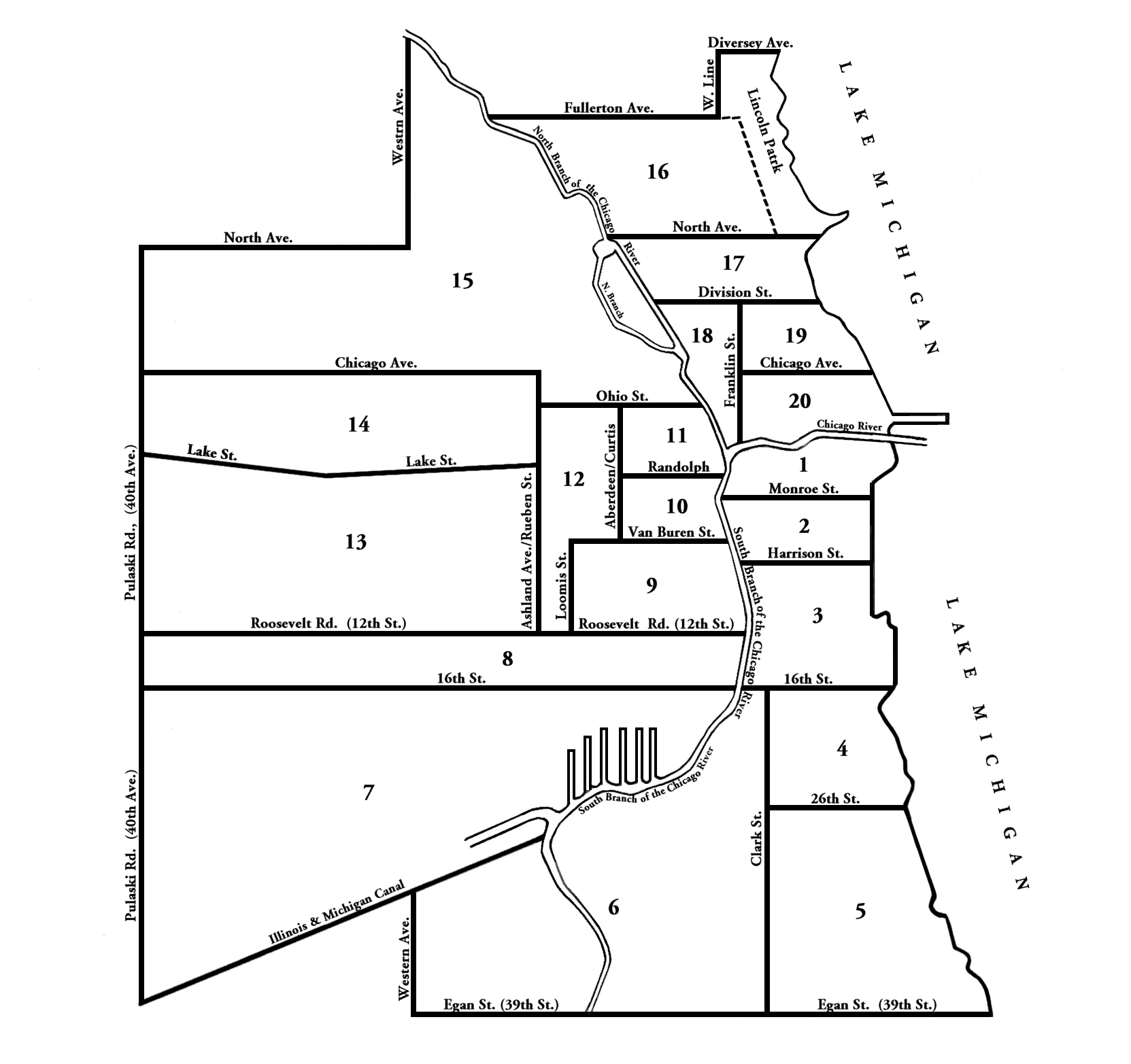
Population | 1837 | 1847 | 1853 | 1863 | 1869 | 1876 | Map |
This is how the city’s boundaries were during the Great Fire and when the 1870 Census was taken. Chicago’s population was at 298,977.
|
Ward
|
Division |
North
|
South
|
East
|
West
|
|
1st
|
South
|
Chicago River
|
Monroe St
|
Lake Michigan
|
Chicago River
|
|
2nd
|
South |
Monroe St
|
Harrison St
|
Lake Michigan
|
Chicago River
|
|
3rd
|
South
|
Harrison St
|
16th St
|
Lake Michigan
|
Chicago River
|
|
4th
|
South |
16th St
|
26th St
|
Lake Michigan
|
Clark St
|
|
5th
|
South |
Egan Ave
|
26th St
|
Lake Michigan
|
Clark St
|
|
6th
|
West
|
16th St
|
Egan Ave
|
Western Ave
|
Chicago River
|
|
7th
|
West |
16th St
|
Chicago River
|
I & M Canal
|
40th Avenue
|
|
8th
|
West |
12th St
|
16th St
|
Chicago River
|
40th Avenue
|
|
9th
|
West |
Van Buren St
|
12th St
|
Chicago River
|
Loomis St
|
|
10th
|
West |
Van Buren St
|
Van Buren St
|
Chicago River
|
Curtis St
|
|
11th
|
West |
Ohio St
|
Randolph St
|
Chicago River
|
Curtis St
|
|
12th
|
West |
Ohio St
|
Van Buren St
|
Chicago River
|
Western Ave
|
|
13th
|
North
|
Fullerton Ave
|
North Ave
|
Lake Michigan
|
Chicago River
|
|
14th
|
West |
Chcago Ave
|
Lake St
|
Reuben St
|
40th Avenue
|
|
15th
|
North |
Division St
|
Huron St
|
Lake Michigan
|
Chicago River
|
|
16th
|
North |
Huron St
|
Chicago River
|
Lake Michigan
|
Chicago River
|
| 17th | North | North Ave | Division St | Lake Michigan | Chicago River |
| 18th | North | Division St | Chicago Ave | Franklin St | Chicago River |
| 19th | North | Division St | Chicago Ave | Lake Michigan | Franklin St |
| 20th | North | Chicago Ave | Chicago River | Lake Michigan | Franklin St |
Notes: Bold indicates city limits. 40th Avenue has been changed in later years to Crawford Avenue and is currently Pulaski Road. Egan Ave (39th St) is now Pershing. Reuben Street is Ashland Avenue today.